On or near this date, the expedition passes present Owensboro, Kentucky—then named Yellow Banks for the color of the Ohio riverbank. In this area, fellow traveler Thomas Rodney describes giant cane and numerous waterfowl.[1]Neither captain appears to be keeping a journal as the expedition travels between Louisville and Fort Massac and their precise location on this date is unknown.
Giant Cane
“The cane now grows plenty on both shores.”
—Thomas Rodney, 25 October 1803[2]Dwight L. Smith and Ray Swick, ed., A Journey Through the West: Thomas Rodney’s 1803 Journal from Delaware to the Mississippi Territory (Athens: Ohio University Press, 1997), 135.
Giant Cane (Arundinaria gigantea)
1920 (Detail)
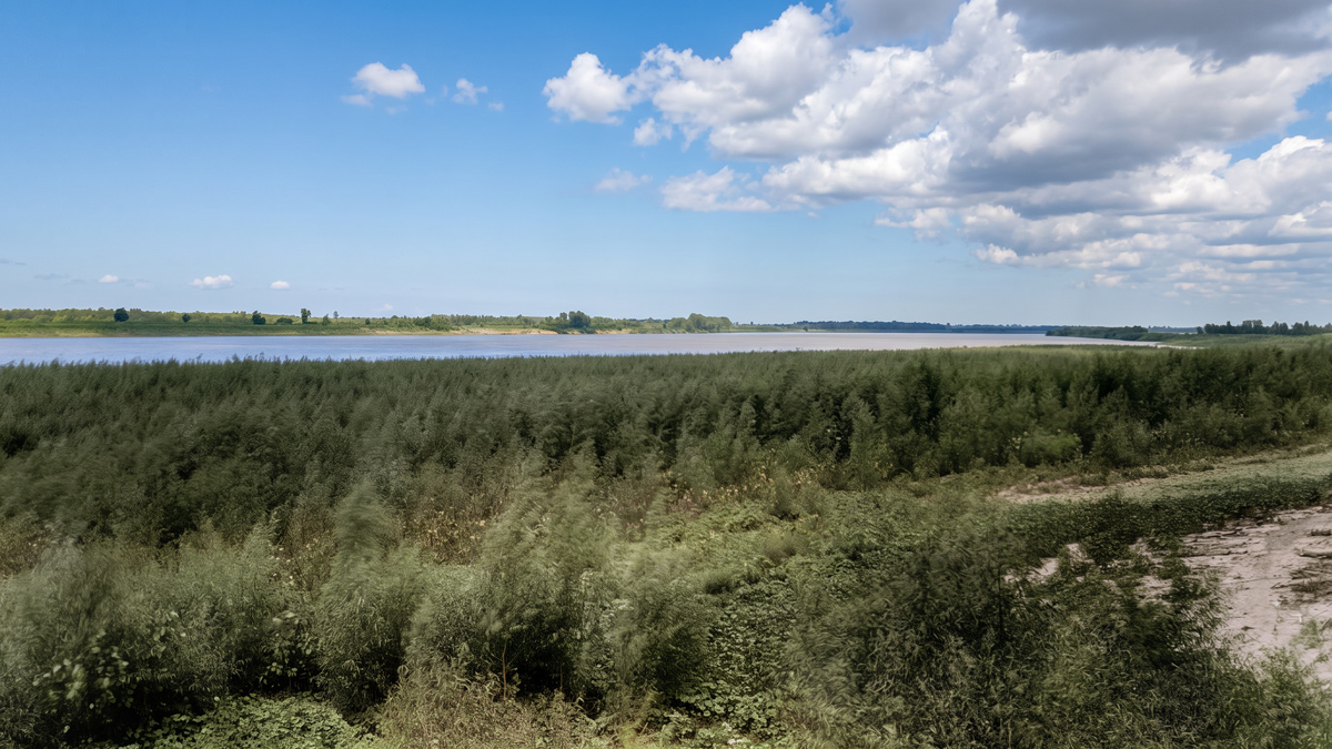
Cleaned up and colorized. Original from Kentucky Geological Survey Photographs, Courtesy Kentucky Historical Society, https://www.kyhistory.com/cdm/compoundobject/collection/PH/id/7714/rec/135.
Noisy Waterfowl
[A]bove and below the Yellow Banks there are vast ponds or little lakes a small distance from the river on both side where wild fowl assemble in vast numbers. We heard several guns fire at them and heard such a tumultious noise of the geese and cranes there, as indicated thousands and tens of thousands.
—Thomas Rodney[3]Rodney, Journal, 138.
Clark documented a similar night on the Columbia River near the Ridgefield National Wildlife Refuge on 4 November 1805:
A cloudy cool morning wind from the West
opposite to our camp on a Small Sandy Island the brant & geese make Such a noise that it will be impossible for me to Sleap.
—William Clark
Yellow Banks
A frontier post was kept here until the Wayne’s treaty at Greenville in 1794. A small creek enters just below the buildings at Yellow Banks. This place takes its name from the yellow appearance of the bank of the river.
Zadok Cramer[4]Zadok Cramer, The Navigator: Containing Directions for Navigating the Monongahela, Allegheny, Ohio and Mississippi Rivers . . . (Pittsburgh: Cramer, Spear and Eichbaum, 1814), 129.
Buffalo Traces
In 1797, William “Bill” Smeathers arrived at Yellow Banks and in short time, built a log cabin that served travelers on the Ohio River. The buffalo preceded him:
Buffalo herds descending river banks over many years produced graded pathways that were the only ready access for people entering parts of the interior by boat. A ‘buffalo landing’ on the high bank of the Ohio River near Yellowbanks Island determined the site of a settlement that grew into the city of Owensboro.[5]Robert W. Kingsolver, The Kentucky Encyclopedia, John E. Kleber, ed. (University of Kentucky Press, 1992), s.v. “Buffalo”.
Experience the Lewis and Clark Trail
The Lewis and Clark Trail Experience—our sister site at lewisandclark.travel—connects the world to people and places on the Lewis and Clark Trail.
Plan a trip related to November 1, 1803:
Notes
| ↑1 | Neither captain appears to be keeping a journal as the expedition travels between Louisville and Fort Massac and their precise location on this date is unknown. |
|---|---|
| ↑2 | Dwight L. Smith and Ray Swick, ed., A Journey Through the West: Thomas Rodney’s 1803 Journal from Delaware to the Mississippi Territory (Athens: Ohio University Press, 1997), 135. |
| ↑3 | Rodney, Journal, 138. |
| ↑4 | Zadok Cramer, The Navigator: Containing Directions for Navigating the Monongahela, Allegheny, Ohio and Mississippi Rivers . . . (Pittsburgh: Cramer, Spear and Eichbaum, 1814), 129. |
| ↑5 | Robert W. Kingsolver, The Kentucky Encyclopedia, John E. Kleber, ed. (University of Kentucky Press, 1992), s.v. “Buffalo”. |