Above the Great Falls of the Missouri, the expedition continues up the Missouri River in eight dugout canoes. There, the river flows along and through the eastern arms of the Rocky Mountains. Clark lists each river constriction as a gate, gap, or narrow.
Clark’s Gates of the Rocky Mountains (1814)
To see labels, point to the map.
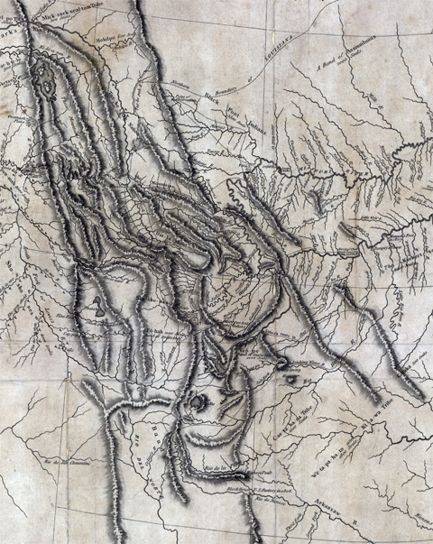
American Philosophical Society, Philadelphia.
| Clark’s description | Date | Present-day name | |
|---|---|---|---|
| 1. | Rockey Mountains at Pine Island rapid | 16 July 1805 | Tower Rock |
| 2. | Great Gate of the Rock Mouts. | 19 July 1805 | Gates of the Mountains |
| 3. | Little Gate of the Mountain | 25 July 1805 | Toston Dam, Lombard |
| – | three forks of Missouri | 27 July 1805 | Three Forks, Headwaters of the Missouri |
| 4. | Narrows of the 3d Mountain | 1 August 1805 | Jefferson Canyon |
| 5. | 4th Gap of the Mountain | 15 August 1805 | Rattlesnake Cliffs |
| 6. | Rapid at the narrows of 5th Mtn. | 16 August 1805 | Beaverhead Canyon Gateway |
1 From Clark’s list of “Estimated Distances”.
Below Three Forks, Montana, the Missouri River ends—fed by three forks named by the captains: the Gallatin, Madison, and Jefferson. They continue up the Jefferson until it too forks into three rivers.
The Beaverhead River is only a sixth the size of the Missouri, and the enlisted men must walk the heavy dugouts up the shallow rapids. They are encouraged when Sacagawea sees familiar landmarks such as Beaverhead Rock.
To get to the waters of the Columbia, they would need horses. The captains take turns scouting ahead by land to find the Shoshones who they hope will have horses. While crossing the Continental Divide at Lemhi Pass, Lewis finally meets them.
Clark would continue with most of the party moving the boats up the shallow Beaverhead. By the time they reach the end of the navigable river, Lewis and a group of Shoshones are waiting for them. One journalist would later name the place Fortunate Camp.
The Lemhi Shoshones
by Stephen E. Ambrose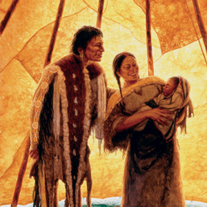
The Lemhi Shoshones were the first Indians they had seen since leaving the Hidatsas and Mandans. In describing them, Lewis was breaking entirely new scientific ground. His account is therefore invaluable as the first description ever of a Rocky Mountain tribe, in an almost pre-contact stage.
Mapping the Rockies
Expectation v. reality
by Joseph A. Mussulman, Robert N. Bergantino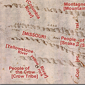
Clark evidently began compiling a map of the Northern Rockies after meeting with Hugh Heney at Fort Mandan on 18 December 1804, and continued adding information acquired from other traders, as well as from Indians. The reality, he would find, was much different.
Synopsis Part 3
The Marias River to the Lemhi Valley
by Harry W. Fritz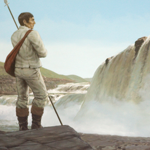
The captains were worried. The expedition was quickly running out of time and space: time to cross the Rockies before winter, and space to find the Shoshones, with their horses and guides. Another month of increasingly toilsome river travel would ensue.
Tower Rock
First Gate of the Rocky Mountains
by Joseph A. Mussulman, Robert N. Bergantino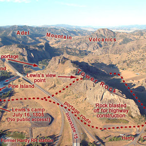
“at this place there is a large rock of 400 feet high wich stands immediately in the gap which the missouri makes on it’s passage from the mountains.”
Oxbow Bend
Land and water
by Joseph A. Mussulman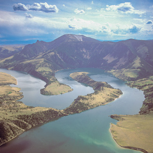
On 19 July 1805, Lewis ‘doubled’ around Oxbow Bend, then 30 feet lower and maybe one-fourth as wide as it is today. Behind the river’s curve, an ancient landmark on the Indian Old North Trail, still stands out.
The Bears Tooth
Key landmark on the Old North Trail
by Joseph A. Mussulman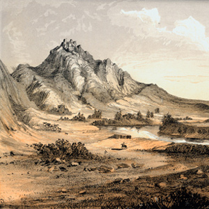
The Bears Tooth was an important landmark on the the ancient Indian road that has come to be known as the Old North Trail. It was included on Nicholas King’s 1804 map, and the captains expected to find it.
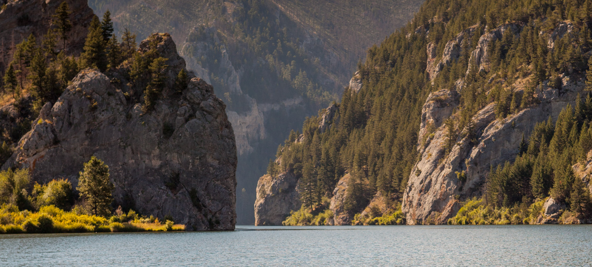
Gates of the Mountains
The second gate
by Joseph A. Mussulman, Robert N. Bergantino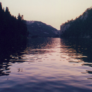
Late in the day on 19 July 1805, Lewis and his party entered a canyon between “the most remarkable clifts that we have yet seen.” They seemed to rise “from the waters edge on either side perpendicularly to the hight of 1200 feet.”
Barbary Coast War
Lewis's "Mahometant yoke"
by Joseph A. Mussulman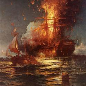
The story of what was known by his detractors as “Jefferson’s War,” opens for us a narrow window on a little known but intriguing episode in Meriwether Lewis’s brief position as the President’s secretary.
Three Forks of the Missouri
Essential geographic point
by Joseph A. Mussulman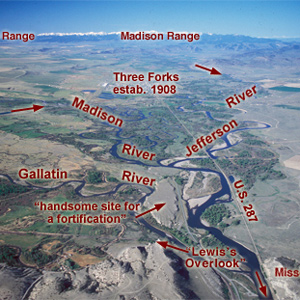
Lewis and his canoes slowly approached the forks, “the current still so rapid that the men are in a continual state of their utmost exertion to get on, and they begin to weaken fast from this continual state of violent exertion.” He described the “extensive and beatifull plains and meadows.”
Little Gate of the Mountain
Lewis's "second grand chain"
by Joseph A. Mussulman, Robert N. Bergantino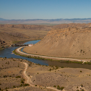
Before arriving at the three forks of the Missouri, Whitehouse wrote that they “passed some rough rockey hills, which we expect from the account we have from the Indian Woman that is with us, to be the commencement of the Second chain of the Rockey Mountains.
Missouri Headwaters Observations
28–29 July 1805
by Robert N. Bergantino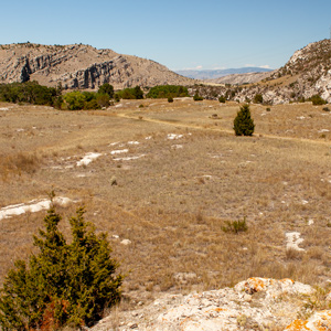
On 28 July 1805, while a fever-ridden Clark drew maps, Lewis began his celestial observations. By late night on 29 July, Lewis had completed ten discrete celestial observations consisting of a total of forty-eight separate angular measurements.
The Jefferson Canyon
The fourth mountain gate
by Joseph A. Mussulman, Robert N. Bergantino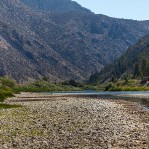
On 1 August 1805, Clark and the expedition’s flotilla of eight dugout canoes pushed up the Jefferson River through “a verrey high mountain which jutted its tremendious Clifts on either Side for 9 Miles, the rocks ragide.” They emerged into a “wide exte[n]sive vallie.”
The Tobacco Root Mountains
Beautiful prairies
by Joseph A. Mussulman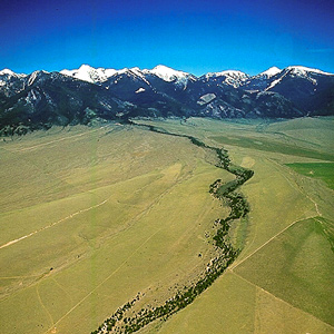
“We proceeded on and passed a large beautiful bottom,” wrote Pvt. Joseph Whitehouse on 2 August 1805, “and Prairies lying on both sides of the River.” On each side of the valley, Sergeant Gass observed, “there is a high range of mountains . . . with some spots of snow on their tops.”
Beaverhead Rock
Sacagawea's landmark?
by Joseph A. Mussulman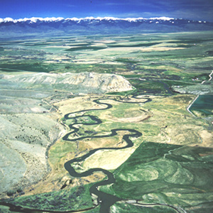
“The Indian woman recognized the point of a high plain to our right . . . . This hill she says her nation calls the beaver’s head from a conceived resemblance of its figure to the head of that animal.”
Fortunate Camp
Western road
by Joseph A. Mussulman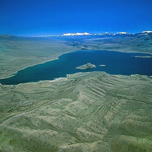
Today the confluence of the Beaverhead River and Horse Prairie Creek is submerged at left of the large island (photo center) in Clark Canyon reservoir, beneath eighty feet of water when the reservoir is full.
The River’s End
End of navigable water
by Joseph A. Mussulman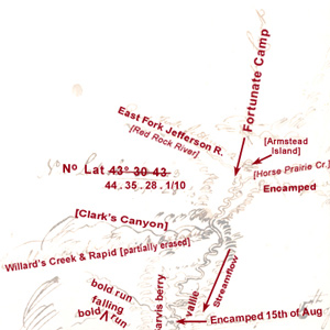
Lewis: “here I halted and examined those streams and readily discovered from their size that it would be vain to attempt the navigation of either any further.”
Across the Great Divide
Over Lemhi Pass
by Joseph A. Mussulman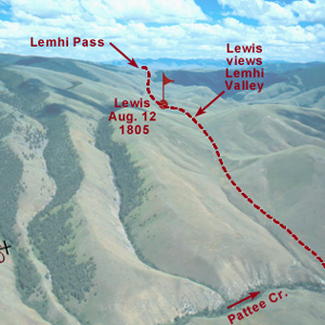
Below the summit of today’s Lemhi Pass, Lewis said that he had reached “the most distant fountain of the waters of the mighty Missouri in surch of which we have spent so many toilsome days and wristless nights.”
Clark’s Lookout
by Joseph A. Mussulman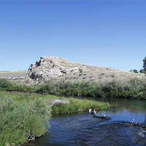
Clark arrived at this “high Point of Limestone rocks” and strolled to its low summit. This was a convenient place from which to take at least three different bearings, making of it a surveyor’s “station” or triangulation point.
The Rattlesnake Cliffs
The 'other' Beaverhead Rock
by Joseph A. Mussulman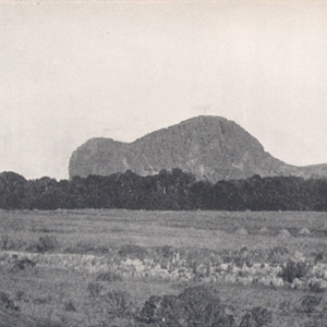
This is the landmark that white settlers believed Sacagawea really meant to identify as Beaverhead Rock . . . .
The Beaverhead Canyon Gateway
Last gate of the Rockies
by Joseph A. Mussulman, Robert N. Bergantino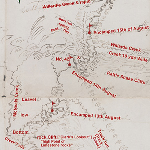
Lewis’s simple, orderly concept of the Rocky Mountains began to crumble. The truth was, this was not the easy portage to the Pacific Ocean they had expected from the beginning. Countless “chains” of mountains still intervened.
Fortunate Camp Observations
18–21 August 1805
by Robert N. Bergantino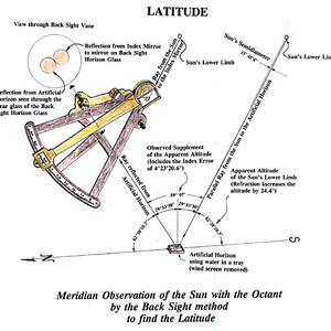
If, as suggested, Fortunate Camp was at 44°59’36″N, how did Lewis, after averaging four observations, come up with a latitude 24 minutes too far south?
Horse Packing
Traveling with horse and mule
by Joseph A. Mussulman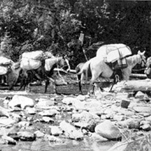
Loading and handling a packhorse is hard work. It demands not only a great deal of physical strength and endurance, but also an eye for balancing a load on the first try, a head full of horse sense, the patience of a saint, and lots of experience.
Experience the Lewis and Clark Trail
The Lewis and Clark Trail Experience—our sister site at lewisandclark.travel—connects the world to people and places on the Lewis and Clark Trail.
![]()
Discover More
- The Lewis and Clark Expedition: Day by Day by Gary E. Moulton (University of Nebraska Press, 2018). The story in prose, 14 May 1804–23 September 1806.
- The Lewis and Clark Journals: An American Epic of Discovery (abridged) by Gary E. Moulton (University of Nebraska Press, 2003). Selected journal excerpts, 14 May 1804–23 September 1806.
- The Lewis and Clark Journals. by Gary E. Moulton (University of Nebraska Press, 1983–2001). The complete story in 13 volumes.
This site is provided as a public service by the![]()
Lewis and Clark Trail Alliance
with cooperation and funding from the following organizations:
- Lewis and Clark National Historic Trail
- Montana Committee for the Humanities
- Idaho Governor's Lewis and Clark Trail Committee
- The Capital Gallery (Lewis and Clark Fort Mandan Foundation)
- Yellowstone Public Radio
Unless otherwise noted, journal excerpts are from The Journals of the Lewis and Clark Expedition, edited by Gary E. Moulton, 13 vols. (Lincoln: University of Nebraska Press, 1983-2001).