Time at Long Camp
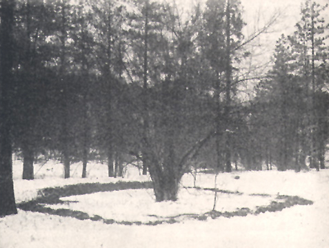
Olin Wheeler took this photograph of the site of Long Camp in 1902. Situated “within 40 paces of the river in an extensive level bottom thinly timbered with the longleafed [ponderosa] pine.” Wheeler scraped the snow away to show the remains of the raised perimeter.
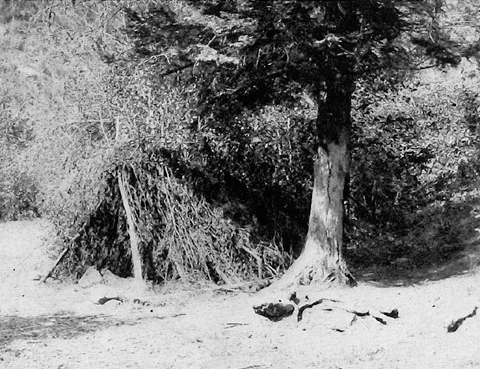
He also shot the photo below of a typical Nez Perce lodge made of sticks and grass.
Spring is shouldering its way up Clearwater Canyon to vanquish mountain snowbanks and green the high swards. It is birthing-time, proffering new life day by day. Volumes of the animal kingdom high and low are there for study from end to end, inside and out: squirrels, reptiles, birds, insects, bears—grizzly-white Hoh-host and black-or-brown Yack-kah. Verities of the vegetable kingdom to fathom: roots, berries, flowers, grasses, shrubs, trees. Specimens of more than 50 new species of plants to press.
Gathering-time Clark: “We have Sixty five horses at this time, most of them in excellent order and fine Strong active horses—.” Lewis: “On examination we find that our whole party have an ample store of bread and roots for our voyage, a circumstance not unpleasing.” Four men are sent to Hohots Ilppilp’s village on Commearp Creek to buy “some pack or lash ropes in exchange for parts of an old sain [sein], fish gigs, pieces of old iron, old files and some bullets,” and to “procure some bags for the purpose of containing our roots & bread.” Three men are detailed over to Lewis’s River (see Ordway’s Salmon Fishing Trip), where the spring salmon had arrived, to buy some fresh seafood. Sacagawea does her part, “gathering the roots of the fenel Called by the Snake Indians Year-pah for the purpose of drying to eate on the Rocky mountains.”
Healing-time “Our invalids are all on the recovery.” Fifteen-month-old Pomp has nearly recovered from an eight-day bout with something—mumps, maybe. An outpatient clinic for the neighbors—mostly eyewash. Lewis wishes he could use Benjamin Franklin’s electric shock treatment to cure an elderly man of paralysis.
Talking-time Lewis explains “the views of our government with respect to the inhabitants of this Western part of the Continent, their intention of establishing tradeing houses for their relief, their wish to restore peace and harmony among the natives, the Strength welth and powers of our Nation &c. to this end we drew a map of the Country with a coal on a mat in their way, and by the assistance of the Snake boy and our intrepeters were enabled to make ourselves under stood by them altho’ it had to pass through French, Minnetare, Shoshone and Chopunnish languages.”
Learning-time How to build a rain-proof lodge of brush and grass; “is much the best tents we have.” How the Nez Perce steam bear meat: “much more tender than that which we had roasted or boiled.” How to castrate a “stone horse”—a stallion; “I have no hesitation in declaring my beleif that the indian method of gelding is preferable to that practiced by ourselves.—” Learning the Nez Perces’ names for nine rivers east of the mountains. A lesson on money, namely blue beads, which “among all the nations of this country may be justly compared to goald or silver among civilized nations.”
Friendship-time On 26 May 1806 a small canoe is finished, to serve for commuting across the Clearwater and back. Four days later it sinks (shades of the ill-fated “iron boat”) and even defies the efforts of a large party of Indians to raise it. Neighborly Hohots Ilppilp says that whenever the explorers need meat they are welcome to kill any of his horses they wish. That is a gesture, Lewis admitts, “which would do honour to such as bost of civiliation; indeed I doubt whether there are not a great number of our countrymen who would see us fast many days before their compassion would excite them to a similar act of liberality.” Betimes they seesaw with the Nez Perce over guide services. Play games, shoot at a mark, race horses. Tunnachemootoolt and Hohots Ilppilp arrive on the south side of the river “with a party of a douzen of their young men; they began to sing in token of friendship as is their custom.” Good feelings.
Biding-time Waiting for June’s full moon—watching the river rise—reading the daily calendar of nature’s tassel-time. “We have summer spring and winter within the short space of 15 or 20 miles.”
Kamiah, Place of Rope Litter
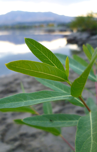
Dogbane, Apocynum cannabinum
© 2011 by Thayne Tuason. This file is licensed under the Creative Commons Attribution-Share Alike 4.0 International license.
About seven species of the genus Apocynum are found worldwide, but only two of them, A. cannabinum and A. androsaemifolium are native to North America. The latter, commonly known as spreading dogbane, was once used for birth control by the women of various tribes, but not among the Nez Perce.
The stems were harvested in October. After the thin outer bark was scraped off and discarded, the woody, hollow core of the stem was removed and also discarded, giving the place its name, kamiah, meaning “place of rope litter.” The remaining pliable inner fibers were then rolled between the hands or against the bare thigh, then twisted and spliced together to produce strong, durable thread, string, and rope. The cordage was used to make fishing lines, nets, and bowstrings, or was woven into bags, moccasins, mats, bedding, straps, and the like.[1]See Primitive Ways, http://www.primitiveways.com/hemp_dogbane.html (accessed 12 December 2004).
Chopunnish and Other Name Calling
Upon its return from the Pacific coast in the spring of 1806, the expedition camped on the Clearwater River near present-day Kamiah (pronounced KAM-ee-eye) from 14 May 1806 until 10 June 1806, waiting for the snow to melt on the crest of the Bitterroot Mountains. The captains themselves didn’t name their camp here, but historians have come to call it Camp Chopunnish, Long Camp, or Camp Kamiah.
“Chopunnish” (pronounced Chop-PUN-ish) was the name Lewis and Clark mistakenly understood these people called themselves. Actually, they called themselves Tsoop-nit-paloo, “people from the mountains.” The sign-language gesture for the word, the index finger pointing upward, then horizontally in front of the face. It was later interpreted by French Canadians to mean “Nez Percé,” or “pierced nose.” The French pronunciation would be NAY pear-SAY, but the people themselves now say either NEZ-purse or nez-PURSE. Their neighbors variously called them “dark brown,” “people under the tule,” and “Khouse eaters.”[2]Khouse, or cous (pronounced cowz) is Lomatium cous, a staple food of Rocky Mountain Indians.
Like many common tribal names, this one was coined by outsiders, and based on observed traits or characteristics that were not necessarily correct. Consider the name Indian, which 15th-century European explorers, having mistaken the coast of South America for the coast of the Indies, imposed on the people they found there. Unfortunately, it still implies that all of those people represent a single culture.
The Nez Perce didn’t usually pierce their noses, though “chopunnish” has been said to have come from a word in the Sahaptin language meaning “piercing people,” although it most likely came from a sign-language gesture for “coming from the mountains,” or “the walking-out people.” Their name for themselves is Nee-me-poo, which means “the real people.”
Not that there’s anything wrong with pierced noses, or ears, or anything else, of course. In one culture or another, it’s one of those fads that come and go from generation to generation.
Leaving
Nez Perce Lodge
Olin D. Wheeler, The Trail of Lewis and Clark. See also Wheeler’s “Trail of Lewis and Clark”.
Elliott Coues, in 1893, will name this bivouac Camp Chopunnish.[3]Elliott Coues (pronounced cowz), ed., History of the Expedition under the Command of Lewis and Clark. . . . (1893. Reprint, 3 vols., New York: Dover, 1965), 3:1009n. Its occupants know it only as “our camp.” It lacks the seasonal permanency of a winter establishment like Fort Mandan or Fort Clatsop. Each man has a foot poised in his own mind, ready to step out for home on a moment’s notice. The travel season in these northern latitudes lasts from ice-out to ice-in, and here in the canyon the hot sun drives men to the shade of their brush lodges by mid-day, reminding them that snow in the mountains is shrinking while they tarry. Every man can imagine what the High Plains look like, teeming with buffalo steaks and elk roasts on the hoof. By the first of June, nearly one-third of the open season is history, and still that icy barrier intervenes. Besides, they’ve run out of tradable stuff, and must get back to those caches at Fortunate Camp, White Bear Islands, and the mouth of the Marias River.
By 2 June 1806, Lewis is fed up with both the situation and the prospects:
having exhausted all our merchandize we are obliged to have recourse to every subterfuge in order to prepare in the most ample manner in our power to meet that wretched portion of our journy, the Rocky Mountain, where hungar and cold in their most rigorous forms assail the waried traveller; not any of us have yet forgotten our suffering in those mountains in September last, and I think it probable we never shall.
It will be almost mid-July before they are finally sprung from the bonds of the Rockies and speeding toward September next.
Monday, 9 June 1806:
our party seem much elated with the idea of moving on towards their friends and country, they all seem allirt in their movements today; they have every thing in readiness for a move, and notwithstanding the want of provision [the meat is all gone; they’re subsisting on roots] have been amusing themselves very merrily today in runing footraces pitching quites [quoits], prison basse &c.
It was time to go.
Long Camp Revisited
Long Camp Today
© 2021 by Kristopher K. Townsend. Permission to use granted under the Creative Commons Attribution-Share Alike 4.0 International license.
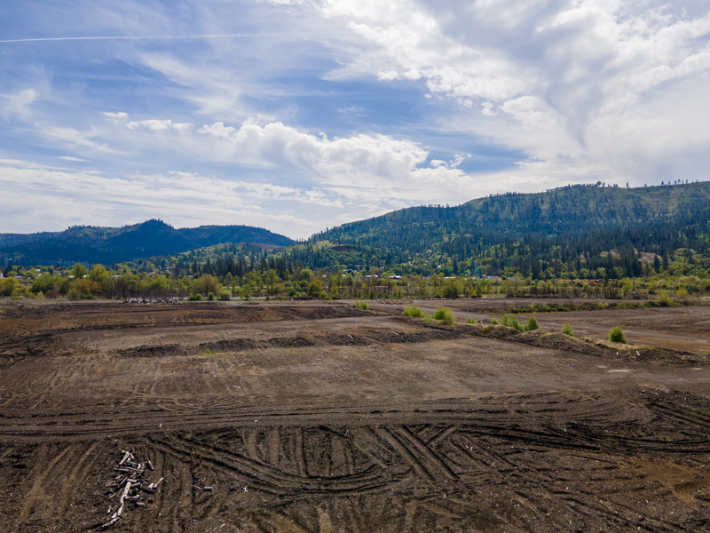
By 2021, the lumber mill built on the Lewis and Clark Expedition’s Long Camp site had closed.
The site of the Corps of Discovery’s camp from 14 May until 10 June 1806 is believed to have been located near the left (north) end of the turn-span bridge pictured below.[4]Research Associate Robert N. Bergantino, of the Montana Bureau of Mines and Geology in Butte, Montana, has estimated its location at 46° 14′ 31″ N, 116° 02′ 04″ W. Find it … Continue reading They set up camp around an old foundation for a Nez Perce lodge, which in Lewis’s judgment was “a very eligible spot for defense”—as if that were necessary with the congenial Nimiipuu as neighbors. Furthermore, it situated them “in the vicinity of the best hunting grounds from Indian information.” They stacked their baggage in the hole, which was about 30 feet in diameter and four feet deep, with its perimeter enhanced by a dirt wall some 3-1/2 feet high. They built a shelter over their stores, then erected their tents of sticks and grass in the Nez Perce style just outside the perimeter. It was a crossroads of sorts. They drove their horses safely across a shallow ford, even though it was “150 yds wide at this place and extreemly rapid.”
The journalists had no name for their camp, but Elliott Coues, who annotated Nicholas Biddle‘s 1814 paraphrase of the journals in 1893, dubbed it Camp Chopunnish.
Crossing the Clearwater
The captains ordered a detail of soldiers to carve a canoe to use for fishing and to commute across the Clearwater to the Indian villages. A few days later the craft, which had a capacity of 12 persons, struck a rock, split open, sank, and defied even the efforts of a group of concerned Nez Perce men to raise her.
In the latter part of the century, a ferry was established here to carry wagons loaded with freight and agricultural products back and forth across the river. Late in the 1890s, a bridge was built to carry the rails of the Union Pacific Short Line to the south side of the canyon, where it terminated in the South Fork canyon at Stites, a few miles south of Kooskia. A wagon road up the head of the steep and narrow South Fork canyon—more or less on the Indian road Ordway and his companions descended on 2 June 1806—was the principal conduit carrying freight and agricultural produce to and from the Nez Perce and Camas prairies.
The bridge is a classic example of the “turn-span” or “center pivot” type that was engineered late in the 19th century to accommodate the locomotive and the steamboat, the two main modes of steam-powered transportation that were vying for the increasing traffic in the West during the 1880s and ’90s. It could be turned on its central pivot to let boats pass through, then closed to accommodate railroad trains. On 8 May 1896, the sternwheeler Lewiston became the first and last steamboat ever to reach Kooskia. The bridge, built at great expense by the same company that owned the railroad, was completed in 1899, opened and closed once just to be sure it worked, and never opened again.
Ironically, a counterpart to this turn-span structure was built at about the same time on the Missouri River a short distance upstream from Fort Benton. It is as if, despite Lewis and Clark’s most important discovery to the contrary, American entrepreneurs acted for the next century as if there really was, as Jefferson had hoped, “a practicable water communication across this continent for the purposes of commerce.”
Further reading:
Alvin M. Josephy, Jr., The Nez Perce Indians and the Opening of the Northwest. Abridged edition; Lincoln: University of Nebraska Press, 1965.
Allen P. Slickpoo, Sr., Noon Nee-Me-Poo: We, The Nez Perces). Nez Perce Tribe of Idaho, 1973.
Notes
| ↑1 | See Primitive Ways, http://www.primitiveways.com/hemp_dogbane.html (accessed 12 December 2004). |
|---|---|
| ↑2 | Khouse, or cous (pronounced cowz) is Lomatium cous, a staple food of Rocky Mountain Indians. |
| ↑3 | Elliott Coues (pronounced cowz), ed., History of the Expedition under the Command of Lewis and Clark. . . . (1893. Reprint, 3 vols., New York: Dover, 1965), 3:1009n. |
| ↑4 | Research Associate Robert N. Bergantino, of the Montana Bureau of Mines and Geology in Butte, Montana, has estimated its location at 46° 14′ 31″ N, 116° 02′ 04″ W. Find it on Google Earth. |
Experience the Lewis and Clark Trail
The Lewis and Clark Trail Experience—our sister site at lewisandclark.travel—connects the world to people and places on the Lewis and Clark Trail.
Discover More
- The Lewis and Clark Expedition: Day by Day by Gary E. Moulton (University of Nebraska Press, 2018). The story in prose, 14 May 1804–23 September 1806.
- The Lewis and Clark Journals: An American Epic of Discovery (abridged) by Gary E. Moulton (University of Nebraska Press, 2003). Selected journal excerpts, 14 May 1804–23 September 1806.
- The Lewis and Clark Journals. by Gary E. Moulton (University of Nebraska Press, 1983–2001). The complete story in 13 volumes.


