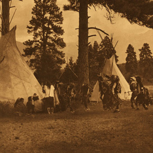
Flathead Salish Dancers
Edward H. Boos (1877–1937)
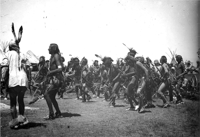
Courtesy Denver Public Library Special Collections.
Edward Boos photographed Salish, Kootenai, and Pend d’Oreille people of the Flathead Reservation mostly in 1905.[1]Randel Metz, “Acclaimed Western Photographer: Edward H. Boos,” Denver Public Library,https://history.denverlibrary.org/news/acclaimed-western-photographers-edward-h-boos, accessed 11 … Continue reading
They prefer to be called the Salish, but throughout their proto-history the people were called the Têtes-Plates. Having learned about the people from French traders, Lewis and Clark at first called them the “flat head” nation but after meeting the people at Ross’ Hole, they called them Tushepaw—likely their spelling of a Lemhi Shoshone word for ‘people with shaved heads’.[2]Prior to 1800, Salish territory went as far east as present-day Billings, Montana, well within the lands of the Crows. Traders at the Knife River Villages likely learned about the Salish during the … Continue reading They never flattened their heads and the name for the tribe in several other indigenous languages, including Plains Sign Language, support ‘shaved heads’ or ‘shaved sides’.[3]Malouf, 312. To assist in navigation and searches, this website sometimes refers to them as Flathead Salish and sometimes Flatheads and Pend d’Oreilles. Their language family is Salishan.
The first whites to encounter the Salish in person were expedition members at Ross’ Hole. Although the journalists had much to say about the encounter, the Salish have said far more.[4]The Salish People and the Lewis and Clark Expedition produced by the Confederated Salish and Kootenai Tribes (University of Nebraska Press, 2005. See also The Discovery Writers, Lewis & Clark in … Continue reading On this website, several elders share their perspective in the article Meeting the Salish. Ron Therriault is interviewed in L&C through Salish Eyes and the story behind Charles M. Russell‘s iconic painting is provided in Ross’ Hole by Patricia Burnham.
At the invitation of the Salish along with the Iroquois working in the fur-trade, Father Pierre De Smet, established the first mission among the Plateau nations, St. Mary’s Mission. After the Steven’s 1855 treaty, the Salish and Pend d’Oreilles would need to move north to the Jocko River, and the mission’s location would follow. Charlo and his small band, would take years before leaving their homes in the Bitterroot Valley.
Selected Pages and Encounters
Montana’s Indian Country
Changes after the expedition
by Rick Newby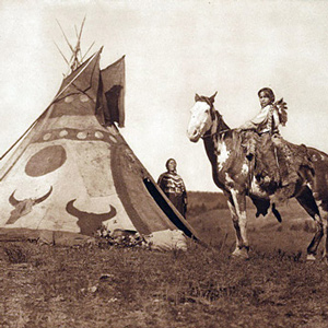
Beginning with the Fort Laramie Treaty of 1851, the U.S. government set the vast area north of the Missouri (approximately 20 million acres) aside as the “Blackfeet Hunting Ground” for the Blackfeet and other tribes—Cree, Assiniboine, Gros Ventre, and Sioux.
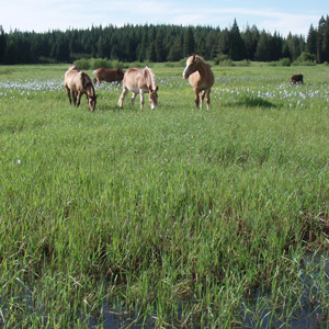
Indian Horses in the PNW
by Barbara Fifer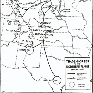
One of the reasons Clark had so much difficulty in purchasing horses at The Dalles in the spring of 1806 is that he was at the very northwestern edge of their dispersal across North America.
L&C through Salish Eyes
An interview with Ron Therriault
by Ron Therriault
Ron Therriault, past council chairman of the Salish-Kootenai Confederated Tribes: “I like to think of the time … We’re looking at 1805 and Lewis and Clark … to look at the people as they were at that time. What were the stories?”
Flag Presentations
by Joseph A. Mussulman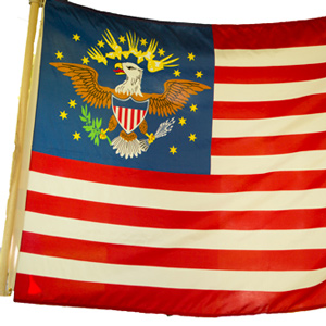
Lewis and Clark usually distributed flags at councils with the chiefs and headmen of the tribes they encountered—one flag for each tribe or independent band.
August 31, 1805
Leaving the Lemhi
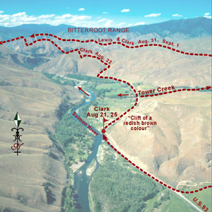
In the morning, the expedition arrives at a Lemhi Shoshone fishing site where Sgt. Gass has been staying. All together, they head down the Salmon River, turn up Tower Creek, and in four miles, encamp.
September 4, 1805
Meeting the Salish Flatheads
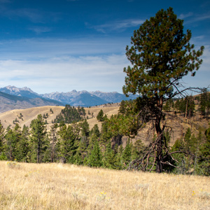
After a night atop the Lost Trail divide, the men thaw their frozen sailcloth, wrap the packs, and load the horses. They then descend to present Ross’ Hole where Flathead Salish give a warm welcome.
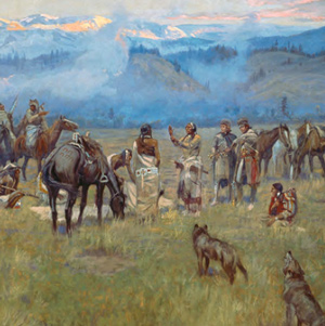
Ross’ Hole
The story behind Russell's painting
by Patricia M. Burnham
The story behind Charles M. Russell’s 1912 painting of the expedition meeting the Bitterroot Salish at Ross’ Hole, one of the great works of Western American art.
Meeting the Salish
Multiple perspectives
by Joseph A. Mussulman
The story of Lewis and Clark meeting the Flathead Salish on 4 September 1805 at Ross Hole is told by one expedition member, four Salish Indians, and one western artist.
September 5, 1805
Flathead Salish council
At present Ross’ Hole, Montana, a council with the Flathead Salish is held using five different languages: Salish-Shoshone–Hidatsa–French–English. Gifts are exchanged, and then horse-trading commences.
September 6, 1805
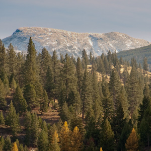
To the Bitterroot River
Taking their leave of the Flathead Salish, the expedition climbs Sula Peak to reach the East Fork of the Bitterroot River. At supper, the hungry members share some parched corn, berries, and two grouse.
September 11, 1805
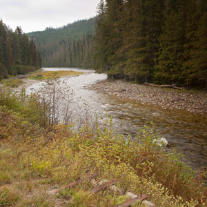
The Northern Nez Perce Trail
After looking for stray horses, the expedition heads up the Indian trail that follows Lolo Creek. They come across a painted tree and stay at a site where the ponderosa bark has been stripped for food.
September 14, 1805
Colt Killed Creek
Leaving Glade Creek, the expedition soon leaves the Northern Nez Perce Trail. Having no meat, Lewis issues portable soup but ends up killing a colt. They continue to a small island in the Lochsa River.
June 23, 1806
Three Nez Perce guides
While waiting at Weippe Prairie for mountain snow to melt, the hunters imitate bleating fawns to call in the does. Three Nez Perce guides arrive, and all is made ready to cross the Bitterroot Mountains.
Notes
| ↑1 | Randel Metz, “Acclaimed Western Photographer: Edward H. Boos,” Denver Public Library,https://history.denverlibrary.org/news/acclaimed-western-photographers-edward-h-boos, accessed 11 October 2021. |
|---|---|
| ↑2 | Prior to 1800, Salish territory went as far east as present-day Billings, Montana, well within the lands of the Crows. Traders at the Knife River Villages likely learned about the Salish during the Crows’ annual visits there. Carling I. Malouf, Handbook of North American Indians: Plateau Vol. 12, ed. Deward E. Walker, Jr. (Washington, D.C.: Smithsonian Institution, 1998), 298. |
| ↑3 | Malouf, 312. |
| ↑4 | The Salish People and the Lewis and Clark Expedition produced by the Confederated Salish and Kootenai Tribes (University of Nebraska Press, 2005. See also The Discovery Writers, Lewis & Clark in the Bitterroot (Stevensville, Montana: Stoneydale Press, chapter 4. |
Experience the Lewis and Clark Trail
The Lewis and Clark Trail Experience—our sister site at lewisandclark.travel—connects the world to people and places on the Lewis and Clark Trail.
![]()
Discover More
- The Lewis and Clark Expedition: Day by Day by Gary E. Moulton (University of Nebraska Press, 2018). The story in prose, 14 May 1804–23 September 1806.
- The Lewis and Clark Journals: An American Epic of Discovery (abridged) by Gary E. Moulton (University of Nebraska Press, 2003). Selected journal excerpts, 14 May 1804–23 September 1806.
- The Lewis and Clark Journals. by Gary E. Moulton (University of Nebraska Press, 1983–2001). The complete story in 13 volumes.
This site is provided as a public service by the![]()
Lewis and Clark Trail Alliance
with cooperation and funding from the following organizations:
- Lewis and Clark National Historic Trail
- Montana Committee for the Humanities
- Idaho Governor's Lewis and Clark Trail Committee
- The Capital Gallery (Lewis and Clark Fort Mandan Foundation)
- Yellowstone Public Radio
Unless otherwise noted, journal excerpts are from The Journals of the Lewis and Clark Expedition, edited by Gary E. Moulton, 13 vols. (Lincoln: University of Nebraska Press, 1983-2001).