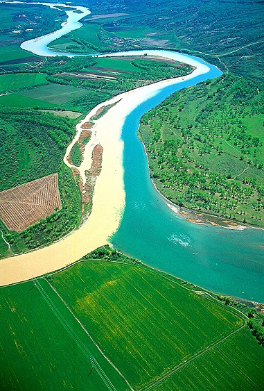
Clark explores the Milk River and sees wide plains, large herds of bison, and distant smoke. Sacagawea brings Clark breadroot, an important Indian food source. Finding where an Assiniboine Indian recently worked on a pronghorn hide, Lewis wishes to avoid an encounter.
Milk River
the water of this river possesses a peculiar whiteness, being about the colour of a cup of tea with the admixture of a tablespoonfull of milk. from the colour of it’s water we called it Milk river.
—Meriwether Lewiswe are willing to believe that this is the River the Minitarres [Hidatsas] Call the river which Scolds at all others
William Clark
Clark’s View
Capt Clark . . . informed me that he had a perfect view of this river and the country through which it passed for a great distance (probably 50 or 60 Miles,) that the country was level and beautifull on both sides of the river, with large herds of Buffaloe distributed throughout
—Meriwether Lewis
Sacagawea Gathers Breadroot
in walking on Shore with the Interpreter & his wife, the Squar Geathered on the Sides of the hills wild Lickerish, & the white apple as called by the angegies and gave me to eat, the Indians of the Missouri make great use of the white apple dressed in different ways—
—William Clark
Unwanted Encounter
we saw where an Indian had recently grained, or taken the hair off of a goatskin [pronghorn hide]; we do not wish to see those gentlemen just now as we presume they would most probably be the Assinniboins and might be troublesome to us.
—Meriwether Lewis
Weather Diary
State of thermometer at rise
Weather Wind at rise
State of thermometer at 4 P. M. Weather Wind at 4 P. M. State of the river 41 [above 0] cloudy E. 52 [above 0] cloudy after rain E fallen ¼ in. rain inconsiderable a mear spinkle the bald Eagle, of which there are great numbers, now have their young. the turtledove appears.
—Meriwether Lewis[1]To assist the reader, the editor of this web page has omitted the date column, merged the “State of the river” columns, and spelled out some abbreviations.
Experience the Lewis and Clark Trail
The Lewis and Clark Trail Experience—our sister site at lewisandclark.travel—connects the world to people and places on the Lewis and Clark Trail.
Plan a trip related to May 8, 1805:

The Milk River Confluence is a High Potential Historic Site along the Lewis and Clark National Historic Trail managed by the U.S. National Park Service. Properties surrounding the confluence are owned by the U.S. Army Corps of Engineers, the Fort Peck Indian Reservation, and private owners.—ed.
Notes
| ↑1 | To assist the reader, the editor of this web page has omitted the date column, merged the “State of the river” columns, and spelled out some abbreviations. |
|---|


