On or near this day, the expedition passes booming Shawneetown and the dangerous channels below the mouth of the Wabash River. Perhaps Clark recalled tougher times there.[1]Neither captain appears to be keeping a journal as the expedition travels between Louisville and Fort Massac and their precise location on this date is unknown.
In Washington City, the State Department prepares “An Account of Louisiana” for the press—part of the process to set up an American government in the Louisiana Territory.
Wabash Wrecks
There is a French family settled just above the mouth of the Wabash. We saw the wrecks of a great number of arks there and like to have run on one in the middle of the river below the mouth of Wabash.
—Thomas Rodney, 29 October 1803[2]Dwight L. Smith and Ray Swick, ed., A Journey Through the West: Thomas Rodney’s 1803 Journal from Delaware to the Mississippi Territory (Athens: Ohio University Press, 1997), 146.
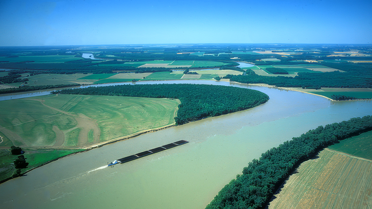
The peaceful confluence shown above is far different from what the expedition encountered. At the mouth of the Wabash were no less than three islands, skeletons of wrecked boats, and the best channel frequently shifted.
Clark at the Wabash (1792)
1814 Map of the Ohio
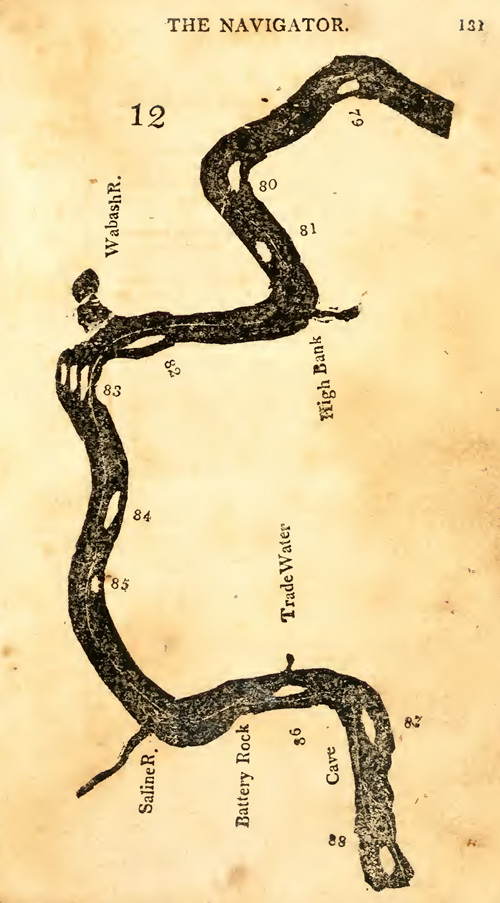
Zadok Cramer, The Navigator, 1814.
Notable locations on this map include the Wabash River, Saline River, and Cave-in-Rock opposite Cave-in-Rock Island (87), and Hurricane Island (88). The channel with the wrecked ship nearly hit by Rodney was likely between one of the three large islands (83) below the Wabash River.[3]Zadok Cramer, The Navigator: Containing Directions for Navigating the Monongahela, Allegheny, Ohio and Mississippi Rivers . . . (Pittsburgh: Cramer, Spear and Eichbaum, 1814), 131–136. The editions of The Navigator available to the captains in 1803 did not include this map.
Delivering military clothing to Fort Knox above Vincennes, William Clark had more than navigation to worry about:
3rd at the Read [Red] Banks Mr. Vigo makes Oars for his Boat, we get Bread Bakd. for to ascend the Wabash R.—
4th. all ready Start at 9 oClock on very well Wind rises we land at Dark Stay untill the Moon Rise start pass the [Diamond] Isle. I hunt Kill a Buck & Bear. . . .
5th. a Buffalow [buffalo] Raft a wreck & walk down to the Wabash overtake the boats; one [boat] arrive from St. Vinvence to take me up the Wabash
6th. Snow Rains and hales all Day I attempted to load the Boat, but find it two cold the French all get Drunk [about] the contractors & Merchant boat Keep out strong guard. Creek & Cherokees & Hourones [Hurons] huntg. opposit this on each side—
—William Clark, December 1792[4]Journal and Memorandum Book of William Clark, 1792–1794, Clark Family Collection, Missouri Historical Society.
Ohio Boating Song
Some rows up, but we floats down
Way down the Ohio to Shawnee TownChorus:
And it’s hard on the beach oar, she moves too slow
Way down to Shawneetown on the OhioNow the current’s got her, And we’ll take up the slack
Float her down to Shawneetown and we’ll bushwhack her backWhiskey’s in the jug, boys; wheat is in the sack
We’ll trade them down in Shawneetown and bring the rock salt backI got a wife in Louisville, and one in New Orleans
And when I get to Shawnee Town gonna see my Indian QueenThe water’s might warm boys, the air is cold and dank
And the cursed fog it gets so thick you cannot see the bankSome rows up, but we floats down
Way down the Ohio to Shawnee Town[5]forum.urbanohio.com/topic/10095-the-falls-of-the-ohio-mostly-maps-amp-diagram-for-history-buff-only accessed on 15 January 2019.
An Account of Louisiana
In Washington City, James Madison informs Thomas Jefferson that “An Account of Louisiana” is on its way to the press and will soon be delivered to Congress:
The Louisiana documents did not come from Mr. Gallatin till a day or two ago. I have this morning delivered 38 revised pages, which will go to the press, a few of which have been some time in the ty⟨pes⟩. There will be abt. ⅓ or ½ as many more. No time will be lost. The bulk of the work will apologize to the House for the delay.[6]“From James Madison to Thomas Jefferson, [5 November] 1803,” Founders Online, National Archives, https://founders.archives.gov/documents/Madison/02-06-02-0025. [Original source: The … Continue reading
Jefferson had distributed questions for Louisiana and the State Department collated answers sent from the likes of Daniel Clark—a member of the American Philosophical Society residing in New Orleans, William Dunbar—a naturalist, astronomer, and explorer from Natchez, and William Claiborne—governor of the Mississippi Territory.
Experience the Lewis and Clark Trail
The Lewis and Clark Trail Experience—our sister site at lewisandclark.travel—connects the world to people and places on the Lewis and Clark Trail.
Plan a trip related to November 5, 1803:
Notes
| ↑1 | Neither captain appears to be keeping a journal as the expedition travels between Louisville and Fort Massac and their precise location on this date is unknown. |
|---|---|
| ↑2 | Dwight L. Smith and Ray Swick, ed., A Journey Through the West: Thomas Rodney’s 1803 Journal from Delaware to the Mississippi Territory (Athens: Ohio University Press, 1997), 146. |
| ↑3 | Zadok Cramer, The Navigator: Containing Directions for Navigating the Monongahela, Allegheny, Ohio and Mississippi Rivers . . . (Pittsburgh: Cramer, Spear and Eichbaum, 1814), 131–136. |
| ↑4 | Journal and Memorandum Book of William Clark, 1792–1794, Clark Family Collection, Missouri Historical Society. |
| ↑5 | forum.urbanohio.com/topic/10095-the-falls-of-the-ohio-mostly-maps-amp-diagram-for-history-buff-only accessed on 15 January 2019. |
| ↑6 | “From James Madison to Thomas Jefferson, [5 November] 1803,” Founders Online, National Archives, https://founders.archives.gov/documents/Madison/02-06-02-0025. [Original source: The Papers of James Madison, Secretary of State Series, vol. 6, 1 November 1803–31 March 1804, ed. Mary A. Hackett, J. C. A. Stagg, Ellen J. Barber, Anne Mandeville Colony, and Angela Kreider. Charlottesville: University of Virginia Press, 2002, pp. 18–19.] |