Joseph Mussulman
Marc A. Hefty photo.
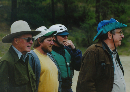
Photo by Bill Bevis.
Left to right: Two concerned dugout canoe owners, one concerned expert paddler, and Joe grinning with delight
Joseph A. Mussulman (1928–2017) was the founding producer, editor and writer for Discovering Lewis & Clark. After five years of preparation and experimentation the website went online in 1998, under the auspices of a non-profit entity called VIAs Inc., and funded by grants from various sources, especially–throughout the bicentennial observance from 2003 to 2006–the Challenge Cost Share Program of the National Park Service. In 2009 the site was taken over by the Lewis & Clark Fort Mandan Foundation of Washburn, North Dakota.
Dr. Mussulman earned his bachelor’s and master’s degrees in music history and literature at Northwestern University in 1950 and 1951. As a Danforth Scholar he earned a doctorate in humanities from Syracuse University in 1967.
He has written and produced a number of interpretive programs in collaboration with audio specialist Richard H. Kuschel, also of Missoula Montana. In 1986, he wrote, narrated, and co-produced a multimedia presentation for the Blaine County Museum (MT) titled Forty Miles from Freedom, about the Non-Treaty Nez Perce Indians’ final battle with the U.S. Army, at the Bear Paw Mountains in 1877. In 2012-13 Mussulman and Kuschel revised the 20-minute onsite production and updated it in High Definition video. In 1994 their interactive self-guided audio-CD tour of Yellowstone National Park, a five-hour program produced for Tour Technologies, Inc., received first prize in the category of media productions from the National Association for Interpretation. Their Two Days to Destiny, an audio interpretive tour of the Little Bighorn Battlefield, won first place from the NAI in 1995.
Mussulman is the author of five articles on Lewis and Clark that appeared in We Proceeded On, the official journal of the Lewis and Clark Trail Heritage Foundation, Inc.: “My Boy Pomp’: About That Name,” Vol. 21, No. 2 (May 1995); “Soundscapes: The Sonic Dimensions of the Lewis and Clark Expedition,” Vol. 21, No. 4 (November 1995); “Men in High Spirits: Humor on the Lewis and Clark Trail,” Vol.22, No. 2 (May 1996); “‘In Greatest Harmoney’: ‘Meddicine Songs’ on the Lewis and Clark Trail,” Vol. 23, No. 4 (November 1997); and “Pomp’s bier was a bar,” Vol. 27, No. 1 (February 2001).
Dr. Mussulman has designed and produced maps for various books, brochures and study guides about Lewis and Clark, including 58 full-color maps illustrating the expedition’s entire route from coast to coast for the travelers’ guide, Along the Trail with Lewis and Clark, by Barbara Fifer and Vicky Soderberg (2nd ed., Helena: Montana Magazine, 2001). Those maps also appeared in the same publisher’s annual Lewis and Clark Travel Planner and Guide. They may be seen in Discovering Lewis & Clark at Discovering Lewis & Clark from the Air. In 1998, he created a poster illustrating the trail from Washington, D.C. to the Pacific, for Farcountry Press.
His other publications include a biography, Dear People . . . Robert Shaw (Indiana University Press,1979; reprint, Chapel Hill, NC: Hinshaw Music, 1996), and Music in the Cultured Generation (Evanston: Northwestern University Press, 1974). From 1987 through 1998 he was the interpretive writer and designer of Montana Afloat, a series of sixteen maps of Montana’s major floatable rivers.
Dr. Mussulman was a 1999 recipient of a Montana Governor’s Arts Award. Several years later he received an award of meritorious achievement from the Lewis and Clark Trail Heritage Foundation “for outstanding contributions in bring to this nation a greater awareness and appreciation of the Lewis and Clark expedition.” In 2005, he received the Montana Governor’s Humanities Award.
Contributions to this Site
John Mullan’s Lolo
Naming Lo Lo's Fork
by Joseph A. Mussulman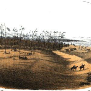
Lt. John Mullan surveyed the Northern Nez Perce road across the Bitterroot Range in 1853-54 to assess its suitability as a railroad route. He never met anyone named Lolo, but was told by an Iroquois guide and interpreter that the creek was called the “Lo Lo Fork,” or “Lo Lo’s Fork.”
Major Owen’s Lolos
An early settler's records
by Joseph A. Mussulman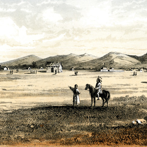
Bitterroot Valley businessman John Owen counted no Lolos among the customers he dealt with at Fort Owen, but he occasionally hired one as a trail-hand.
Bozeman Pass
Of great service
by Joseph A. Mussulman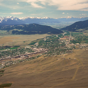
Clark reported, “the indian woman who has been of great Service to me as a pilot through this Country recommends a gap in the mountain more South which I shall cross.” This was one of the few times Sacagawea acted as the guide.
The Great Fall by Air
"Sublimely Grand"
by Joseph A. Mussulman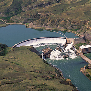
Shortly before noon on the 13 June 1805, Lewis’s ears “were saluted with the agreeable sound of a fall of water,” which “soon began to make a roaring too tremendious to be mistaken for any cause short of the great falls of the Missouri.”
Columbia River Dams
The rough places plain
by Joseph A. Mussulman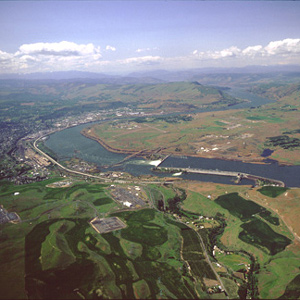
Bonneville Dam, was the first dam to be built on the Columbia River. The slackwater pool it impounds, called Lake Bonneville, eliminated the Cascades as a barrier to commercial shipping, and provided a deep, navigable channel for barges and tugs.
Big Bend of the Missouri by Air
Around the bend
by Joseph A. Mussulman
They paced off the distance across “the gouge,” wrote Clark, and found it to be about a mile and a quarter; he estimated the distance around the oxbow to be thirty miles.
The Osage River by Air
"Delightfull prospect"
by Joseph A. Mussulman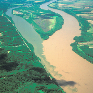
At 4 P.M. on 1 June 1804, the expedition arrived at the mouth of the Osage River, one of the major Indian fords on the lower Missouri.
Lewis, Beethoven, Napoleon
An amazing coincidence
by Joseph A. Mussulman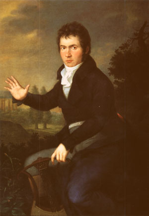
On 7 April 1805 three ‘heroic’ events occurred. The expedition set off from Fort Mandan, and Beethoven premiered his Third Symphony, the “Eroica,” dedicated to Napoleon Bonaparte. It was also the day Great Britain and Russia sealed a fateful alliance against that French emperor.
Leaving the Lemhi Valley
Detour at Tower Creek
by Joseph A. Mussulman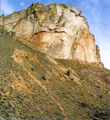
The Salmon winds tortuously through a seven-mile-long canyon where the vertical walls at that time crowded the riverbanks so tightly in several places that Clark and his party were compelled to clamber over “four mountains verry Steap high & rockey.”
Eye Gnats
Hippelates sp.
by Joseph A. Mussulman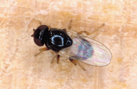
On 11 July 1805 while making canoes above the Falls of the Missouri, Clark wrote “Musquitors verry troublesom, and in addition to their torments we have a Small Knat, which is as disagreeable.”
Illustrating the Great Fall
At the Falls of the Missouri
by Joseph A. Mussulman
After Lewis’s preliminary sketch, later artists and photographers contributed to the visual documentation of the “sublimely grand” waterfall including Barralet, Gustavus Sohon, A. E. Mathews, and F. Jay Haynes.
Three Forks of the Missouri
Essential geographic point
by Joseph A. Mussulman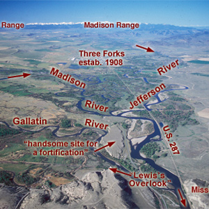
Lewis and his canoes slowly approached the forks, “the current still so rapid that the men are in a continual state of their utmost exertion to get on, and they begin to weaken fast from this continual state of violent exertion.” He described the “extensive and beatifull plains and meadows.”
Missouri River Fur Trade
by Joseph A. Mussulman, W. Raymond Wood
The Corps of Discovery had been, as James Ronda phrased it, “only the latest in a long series of traders and travelers” to visit the tribes living along the Missouri. The Mandans had been visited in 1738 by la Vérendrye from his base on the Assiniboine River.
John James Audubon
(1785–1851)
by Doug Erickson, Joseph A. Mussulman
America’s greatest ornithologist, John James Audubon, was just starting his career when Lewis and Clark returned, and there is ample evidence that he drew inspiration from Lewis and Clark’s writings.
Army Hygiene
by Joseph A. Mussulman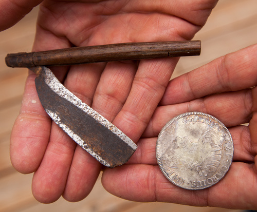
Officers were to see that their men’s hands and faces were daily “washed clean” and their hair combed. Soap was relatively expensive, and if individuals or families couldn’t manage to make their own, they just went without.
Bighorn: Sheep or Goat?
by Joseph A. Mussulman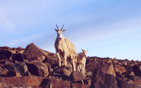
We confront the paradox that Elliott Coues pointed out in 1893—that Lewis and Clark had mistaken goats with wool … for sheep, and sheep without wool . . . for ibexes. Succeeding naturalists heightened the misunderstanding with invidious comparisons.
A ‘Sinque’ Hole
Below the Smoking Place
by Joseph A. Mussulman
Private Whitehouse reported: “Camped at a Small branch on the mountain near a round deep Sinque hole full of water.”
Pryor’s Intended Route
The best of intentions
by Joseph A. Mussulman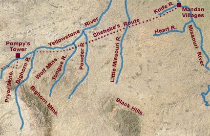
Via the shorter route, Pryor would have arrived at the Knife River villages by about 6 August 1806. A trip to see Hugh Heney at Fort Assiniboine would take another two weeks.
Miller Island
River of the falls
by Joseph A. Mussulman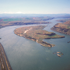
Near the west end of the island, they passed a sizeable tributary local Indians called To war ne hi ooks. The journalists left us no hint that the word they heard as Towarnehiooks was a Chinookan expression meaning “enemies.”
Uniforms
by Joseph A. Mussulman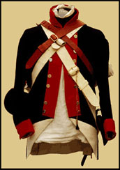
Each enlisted man, as well as the Captains, brought with them their dress uniforms which was worn for formal, official occasions such as dress reviews and parades, courts-martial, and funerals.
Observing Bighorn Sheep
A pictorial essay
by Joseph A. Mussulman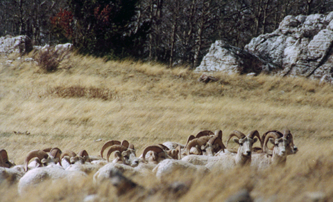
By telling the story of how these photos and videos were created, the behaviors of the bighorn sheep are described.
Lost Hunters
by Joseph A. Mussulman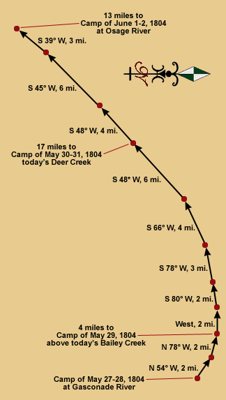
Every hunter, after following the land instead of the river, had to somehow end his day within sight or sound of the party’s camp at a location which no one could have known in advance. They were not always successful.
Blue Lake Meander
Iowa meander
by Joseph A. Mussulman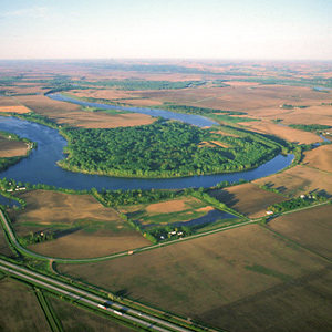
This oxbow was once part of the main channel of the Missouri, but by 1804 the river had already cut it off, turning it into a lake “6 leagues [eighteen miles] around.”
Louisville
Kentucky recruits
by Joseph A. Mussulman
Clark was waiting with seven more recruits who would become permanent members of the contingent soon to be known as the Corps of Volunteers for North Western Discovery.
Wheeler on the Yellowstone
Bozeman Pass and Pompeys Pillar
by Barbara Fifer, Joseph A. Mussulman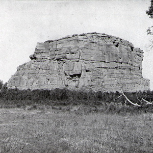
In 1902, Wheeler followed the Northern Pacific’s course over Bozeman Pass and the Yellowstone River promoting both the railroad and the Lewis and Clark Centennial.
The Newfoundland Dog
Seaman's breed
by Joseph A. Mussulman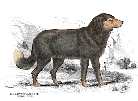
The original Newfoundland was smaller, the body more slender, forehead more arched, the muzzle sharper, and “nearly all of a totally black colour, excepting a bright rust coloured spot above each eye.”
Coyotes
Canis latrans
by Joseph A. Mussulman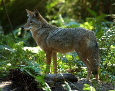
Clark shot “a Prarie Wollf, about the Size of a gray fox bushey tail head & ear like a wolf.” Lewis wrote his description of what proved to be a new species on 5 May 1805, in northeastern Montana.
The Lost Trail Divide
Leaving the Indian road
by Joseph A. Mussulman
Continuing north up the North Fork Salmon River, they leave a good Indian road and must cut their own trail. Were they lost? Sergeant Gass’s laconic remark gives us a hint: “This was not the creek our guide wished to have come upon.”
Lewis’s Woodpecker
Melanerpes lewis
by Joseph A. Mussulman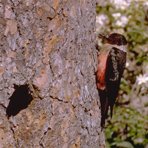
On 27 May 1806, while the expedition was camped in the vicinity of modern Kamiah, Idaho, on the Clearwater River, Lewis described a bird that was “new to science,” with his typical mixture of minute detail and genuine admiration.
Lewis’s Three Wishes
Pencil, pen, and camera obscura
by Joseph A. Mussulman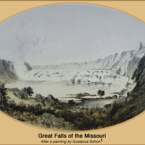
“I wished for the pencil of Salvator Rosa, or the pen of Thompson, that I might be enabled to give to the enlightened world some just idea of this truly magnifficent and sublimely grand object, which has from the commencement of time been concealed from the view of civilized man”
Wheeler on the Columbia
Fish wheels and canneries
by Barbara Fifer, Joseph A. Mussulman
At The Dalles in 1902, a hospitable local citizen helped Wheeler make his way to the brink of the long narrow channel and chasm through which Lewis and Clark took their canoes, where he “overlooked the swirling waters as they boiled and raged.”
The Judith River
by Joseph A. Mussulman
“at the distance of 2½ miles passed a handsome river which discharged itself on the Lard. side, I walked on shore and acended this river about a mile and a half in order to examine it”
Eagles
The bald and golden eagles
by Joseph A. Mussulman
En route to the Pacific Ocean, Lewis and Clark saw both species of eagles that are native to North America: the black-and-white one called the bald eagle, and the brown-and-gold one commonly known as the golden eagle, but which the explorers knew as the grey eagle.
John Evans
Mapping the way
by Joseph A. Mussulman, Kristopher K. Townsend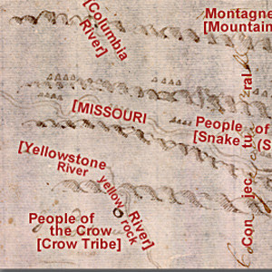
John Evans provided maps of the Missouri River and Rocky Mountains, the most significant outcome of the Mackay-Evans Expedition.
Turtles
Reptiles of the order Testudines
by Joseph A. Mussulman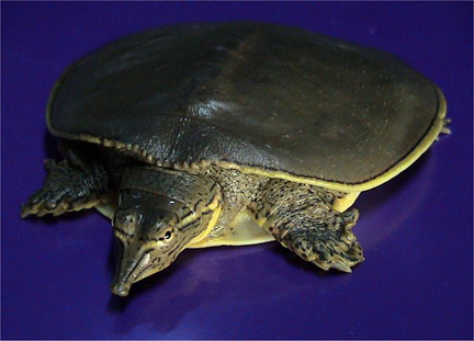
Lewis reported on 26 May 1805, that on a creek he saw “several softshelled Turtles which were the first that have been seen this season; this I believe proceeded reather from the season than from their nonexistence in the portion of the river from the Mandans hither.” He was probably correct.
Meeting the Snake
Water color
by Joseph A. Mussulman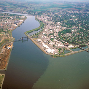
The Corps’ four-day trip to this point from Canoe Camp on the Clearwater in their five crowded dugouts was a taste of things to come.
Father De Smet’s Arrival
Did they know any Lolos?
by Joseph A. Mussulman
Among the most faithful of the missionaries’ converts to Catholicism was a half-breed trapper named Lolo who was killed by a grizzly bear in November 1850.
Friedrich Wilhelm von Steuben (1730–1794)
Early American Army trainer
by Joseph A. Mussulman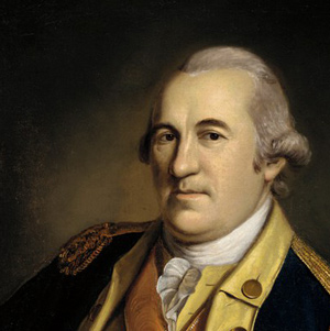
Until he presented his services to General Washington at Valley Forge, the Continental Army still consisted merely of a number of state-sponsored militias that were entirely independent of one another, each operating according to its own rules and regulations.
Beacon Rock by Air
Tidewater mark
by Joseph A. Mussulman![]()
On 31 October 1805, Clark first saw this “remarkable high detached rock,” the eroded core of an ancient volcano, which he estimated stood eight hundred feet above the riverbank and was four hundred yards in circumference.
Yankton by Air
Peace parley
by Joseph A. Mussulman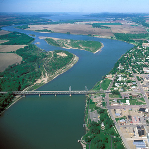
Here they “formed a camp in a Butifull Plain,” erected a flagpole, ran up their large flag, and settled in to wait for the Sioux, whom they had invited to meet with them. On August 30, seventy-five Sioux men of the Yankton tribe ceremoniously entered the expedition’s camp, eager to parley.
The Grand Tower
Demons
by Joseph A. Mussulman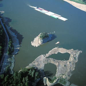
In 1673 French explorers Père Marquette and Louis Joliet listened to local Indians’ warnings about this place and erected a cross atop the ninety-foot-high rock to disempower the demons said to be lurking in the treacherous whirlpool at its base.
The Pirogues
by Joseph A. Mussulman
The two pirogues served as supplementary cargo carriers accompanying the barge from the mouth of the Missouri to the Mandan villages, one of which became the command boat on the return trip from the Marias River to St. Louis.
Sulphur Springs
A cure for Sacagawea?
by David J. Peck, Joseph A. Mussulman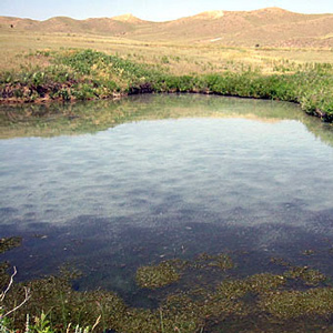
On his return to the mouth of the Marias, Lewis found Sacagawea gravely ill. He had his men cross the river “to procure the water of the Sulpher spring,” “the virtues of which,” Lewis asserted, “I now resolved to try on the Indian woman.”
La Freeman-Custis Expedición
La Gran Excursión
by Dan Flores, Joseph A. Mussulman
Narrado tanto en inglés como en español, Daniel Flores narra la historia de una exploración paralela y sureña ahora casi olvidada.
Prickly Pears
One of nature's greatest pests
by Joseph A. Mussulman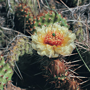
“The prickly pear is now in full blume,” he wrote on a mild early-summer day in 1805, “and forms one of the beauties as well as the greatest pests of the plains.”
The Faces of Sacagawea
Interpretations of an unknown image
by Joseph A. Mussulman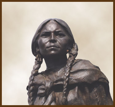
Because the Shoshone woman has been the subject of so many sculptures and paintings, especially since about 1900, we have a rich heritage of artists’ conceptions to contemplate.
Sharp-tailed Grouse
Tympanuchus phasianellus
by Joseph A. Mussulman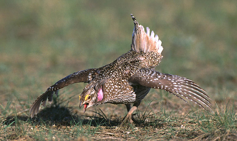
Elliott Coues, whose scientific interest centered on ornithology, in 1893 declared Lewis’s “Grouse or Prarie hen” to be the Oregon ruffed grouse, at that time classified as Bonasa umbellus sabinei (Ord) Coues.
Travelers’ Rest Creek
Today's Lolo Creek in Montana
by Joseph A. Mussulman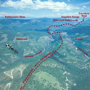
At 3 o’clock in the afternoon, 11 September 1805, Toby led the Corps of Discovery out of Travelers’ Rest camp toward the Bitterroot Mountain barrier.
Lewis’s Hunting Accident
Lewis's closest call
by Joseph A. Mussulman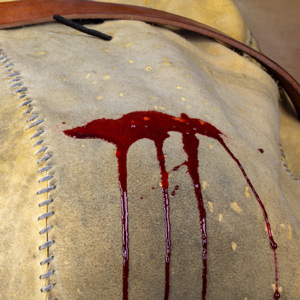
The most serious hunting mishap, and surely the most memorable episode in Lewis’s frequently referenced “chapter of accedents,” was the moment on 11 August 1806 when Pierre Cruzatte shot him in the buttocks.
Sage Grouse
Centrocercus urophasianus
by Joseph A. Mussulman, Mark Behan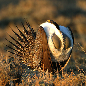
“The Heath Cock or cock of the Plains is found in the Plains of Columbia and are in great abundance from the enterance of Lewis’s river to the mountains which pass the Columbia between the Great falls and Rapids of that river.” Thus we have a historic account of sage grouse range and abundance.
Hungery Creek
And a return to Bald Mountain
by Joseph A. Mussulman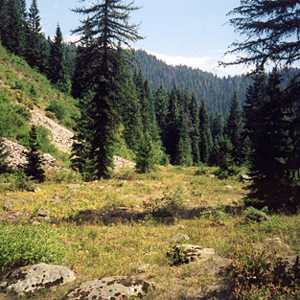
By the evening of 17 September 1805, their seventh sleep west of Travelers’ Rest, it was obvious to the captains that the Indians’ assurance that they could cross the mountains in six days was false, whereas the prediction that they would find no game there was all too true.
The Articles of War
Rules for soldiers
by Joseph A. MussulmanThe expedition’s enlisted men were obliged to comply with the basic military rules and regulations contained in two distinct official documents that had been written in the initial heat of the Revolutionary War.
Jean-Bapiste Lolo
Another corporeal Lolo
by Joseph A. Mussulman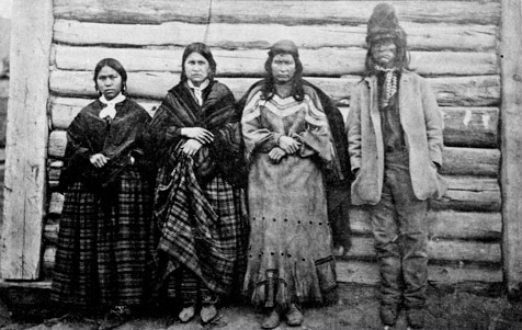
He spent most of his 70 years at Fort Kamloops in British Columbia and is not known to have traveled as far south as today’s Lolo, Montana.
Cascade Mountains at Dawn
by Joseph A. Mussulman
In 1838, a patriotic citizen started a campaign to change the Cascade Mountains into the “Presidential Range.” This was to include renaming Mount Hood after John Adams.
Mosquito Etymology
Names and classifications
by Joseph A. Mussulman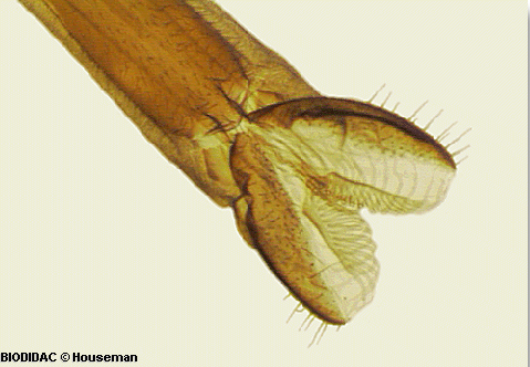
Potts, might have called it a grosser Mücke (large gnat) or a Stechmücke (biting gnat). Labiche and Drouillard might have called it a cousin or a moucheron. But ever since early Colonial days it has chiefly been known in America by its Spanish name, mosquito.
Fort Clatsop Elk
Cervus canadensis roosevelti
by Greg Tollefson, Joseph A. Mussulman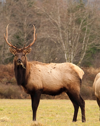
Fort Clatsop’s location was chosen in part because, as some Clatsop Indians had advised the captains, there were more elk on the south side of the river than on the north. The subspecies found there was named in 1898 to honor Theodore Roosevelt.
Wild Roses
Rosa woodsii
by Joseph A. Mussulman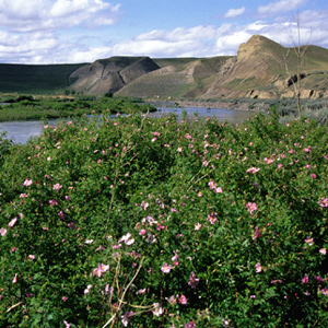
Meriwether Lewis was sufficiently familiar with the genus back home to recognize the new species he termed the “small rose of the prairies,” which he found on 5 September 1804, in present-day Nebraska near the mouth of the Niobrara River.
Over Tillamook Head
Clark's point of view
by Joseph A. Mussulman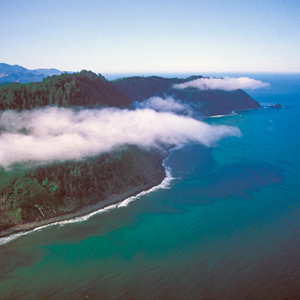
After passing the salt works and continuing along the “round Slippery Stones under a high hill,” Clark related, “my guide made a Sudin halt, pointed to the top of the mountain and uttered the word Pe Shack which means bad, and made Signs that we . . . must pass over that mountain.
Jefferson-Lewis Cryptology
Jefferson's ciphers
by Joseph A. Mussulman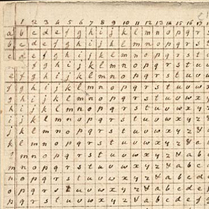
It was Thomas Jefferson who gave cryptography in America its greatest impetus. Sometime in 1803 Jefferson presented Meriwether Lewis with a cipher based on a square table or tableau used to create a substitution cipher.
A Bold Diplomatic Plan
The need for five separate details
by Joseph A. Mussulman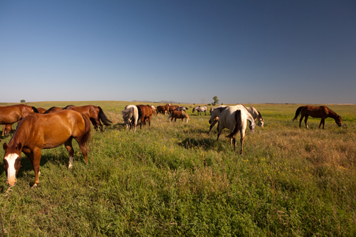
There was no Northwest Passage by water; and the portage they found took much longer than a day. The political repercussions from that alone could be immensely embarrassing to Jefferson. Something had to be done….
An Offer to Raise Jean Baptiste
Clark's promises
by Joseph A. Mussulman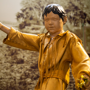
Clark’s affection for Sacagawea’s little boy, Jean Baptiste, becomes evident while canoeing down the Yellowstone River. This article analyzes Clark’s offer to his father, Toussaint Charbonneau, to raise the child.
The Marias River by Air
Narrow escape
by Joseph A. Mussulman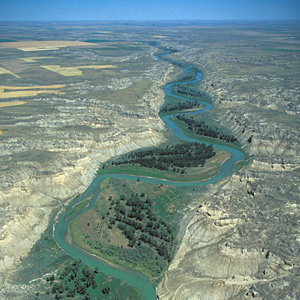
“I sliped at a narrow pass of about 30 yards in length and but for a quick and fortunate recovery by means of my espontoon I should have been precipitated into the river down a craggy pricipice of about ninety feet.”
The Tambourine
by Joseph A. Mussulman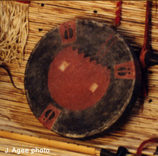
Instruments resembling tambourines are mentioned several times in the journals, but always in descriptions of Indian music, except for Sergeant Ordway’s comment on New Year’s Day of 1805.
Fort Union
Upper Missouri developers
by Joseph A. Mussulman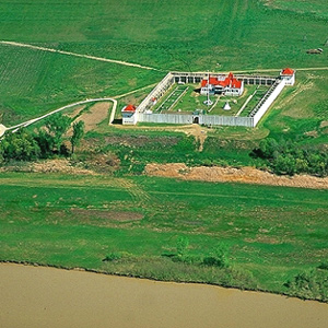
This is where, in 1828, John Jacob Astor’s American Fur Company built Fort Union, which remained the axis of Indian-American commerce on the Upper Missouri until the late 1860s.
Postscript to the Purchase
Mapping the American future
by Joseph A. Mussulman, Pierce Mullen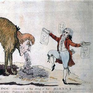
Determining the extent of the upper Missouri watershed was the single most important task Lewis and Clark faced. Their search for the westernmost source of the Jefferson River nearly cost them their lives.
Gritty American Place-Names
Robert Southey's criticism
by Joseph A. Mussulman
To the European Romantics, the gritty names those American explorers uttered sounded like throwbacks to a cruder, more barbarous epoch, boding ill for the future of poetic taste in the New World. In 1815, Robert Southey found plenty of evidence.
Charles M. Russell NWR
Missouri Breaks
by Joseph A. Mussulman
The wind against them again on 25 May 1805, the Corps had to tow their boats with ropes. Lewis observed, “the water run with great violence, and compelled us in some instances to double our force in order to get a perorogue or canoe by them.”
Sgt. Floyd’s Memorials
Much Remembered
by Joseph A. Mussulman
Floyd’s grave became a conspicuous point and a historic shrine on the Lewis and Clark trail almost immediately after the expedition was over. The American artist George Catlin painted Floyd’s Bluff in 1832, with the original cedar marker still in place.
The Clearwater Canoe Camp
by Joseph A. Mussulman
Still sick and exhausted from their recent crossing of the Bitterroot Mountains, Lewis, Clark, and their crew arrived on 26 September 1805, at what they called Canoe Camp, on the Clearwater River.
Climbing Wendover Ridge
Leaving the Lochsa
by Joseph A. Mussulman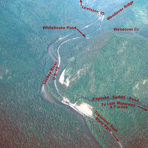
“Several horses Sliped and roled down Steep hills which hurt them verry much The one which Carried my desk & Small trunk Turned over & roled down a mountain for 40 yards & lodged against a tree, broke the Desk…”
Elk Point
Names
by Joseph A. Mussulman
In the vicinity of Elk Point, South Dakota, the captains found a variety of unfamiliar minerals, including what Clark believed were arsenic and cobalt. “Capt. Lewis in proveing the quality of those minerals was near poisoning himself by the fumes & taste.”
Lewis’s Dog Seaman
A working expedition member
by Joseph A. Mussulman
The Shoshones, like all other Indian people, had owned, bred, trained, used, and loved dogs from the dimmest days of their own origins. What was it, then, about this dog that thrilled them so? Lewis called it sagacity.
Outfitting the Expedition
Buying supplies in Philadelphia and St. Louis
by Frank Muhly, Joseph A. Mussulman
The original shopping list contained more than 180 items, including various “Mathematical Instruments”, arms and accouterments, ammunition, clothing, camp equipage, provisions, Indian presents, medicine, and packing materials.
Yellowstone Canoe Camp by Air
Horse thieves
by Joseph A. Mussulman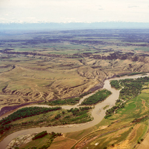
Clark’s party made camp at today’s Park City, Montana, and settled in to build the new canoes and attend to other business. While a few of the men took turns with the three axes they had along, some of the rest, being nearly naked, made elk- and deer-skin clothing.
Lewis’s Branding Iron
by Joseph A. Mussulman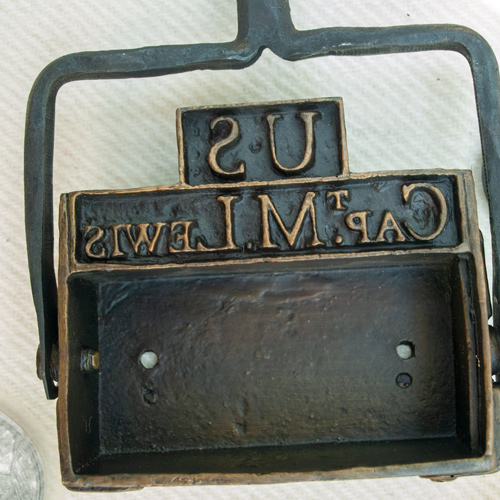
Lewis may have had this branding iron custom-made before he left the East, perhaps at Harpers Ferry, although there is no mention of it in existing records. Such tools commonly were used for marking wooden packing crates and barrels, and on leather bags, until the early 20th century.
Ecola
Whale tale
by Joseph A. Mussulman
By the time Clark and his party got to present-day Cannon Beach, Oregon, on 8 January 1806, the locals had picked the dead whale’s 105-foot-long carcass clean.
Citadel Rock
"Steep black rock"
by Joseph A. Mussulman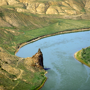
Clark remarked on this “high Steep black rock riseing from the waters edge” as they passed it on 31 May 1805, but he did not give it a name. Citadel Rock, so called during the steamboat era for its fortress-like presence, was an igneous intrusion into a layer of sandstone.
Grouse
by Joseph A. Mussulman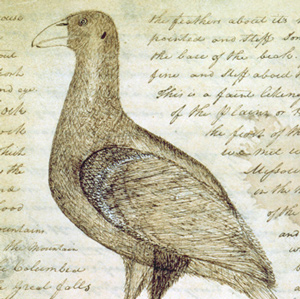
Why did Lewis call the spruce grouse, blue grouse, and Oregon ruffed grouse “Three species of Pheasants?” What species did he actually see?
Lead Powder Kegs
by Joseph A. Mussulman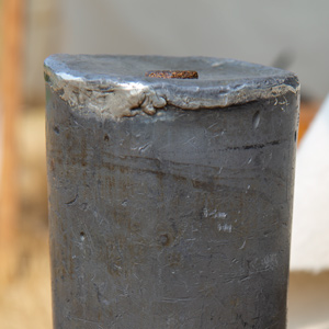
Lewis ordered 52 lead canisters specially made to carry and protect the expedition’s gunpowder.
Grizzly Bear Encounters
Thirteen significant encounters
by Joseph A. Mussulman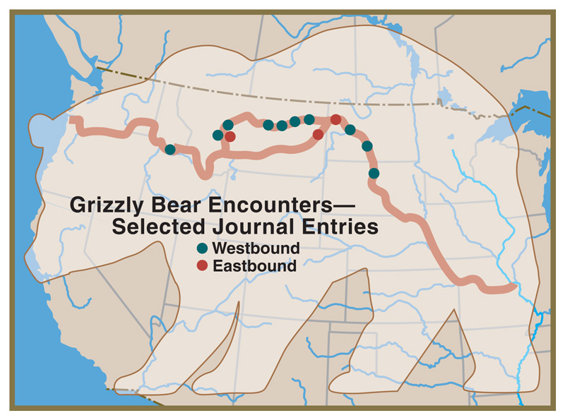
“the Indians give a very formidable account of the strength and ferocity of this anamal, which they never dare to attack but in parties of six, eight or ten persons; and are even then frequently defeated with the loss of one or more of their party.”
Into the Breaks
Fred Robinson Bridge to Judith Landing
by Joseph A. Mussulman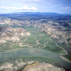
In 1804-5-6 Lewis and Clark called all rough or relatively precipitous elevations, wherever they saw them, “broken” lands; the topography along this 149-mile stretch of the Wild and Scenic Missouri River was clearly the worst they had ever seen.
Ocean in View?
Premature elation
by Joseph A. Mussulman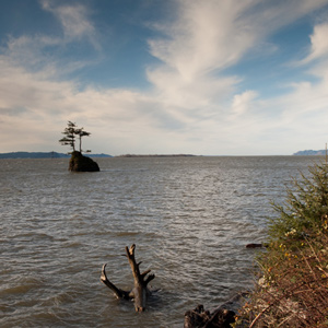
They fancied they could already see and hear the Pacific Ocean, although it was still more than 20 miles away, well beyond their horizon. Clark’s famous exclamation was another instance of the captains’ habit of reacting prematurely.
Mapping the Road to the Buffalo
Clark's interpretation of Lewis's shortcut
by Joseph A. Mussulman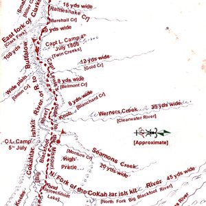
Clark produced this map of Lewis’s route sometime after the Corps was reunited on 12 August 1806, near today’s New Town, North Dakota.
Long-tailed Weasels
Mustela frenata
by Joseph A. Mussulman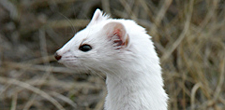
The captains saw their first white weasel at Fort Mandan on 9 November 1804. At Fort Clatsop on Christmas Day, 1805, Sacagawea gave Clark “2 Doz wesels tales.”
Edgar S. Paxson
by Joseph A. Mussulman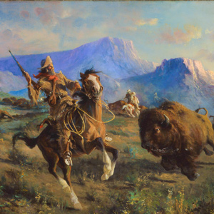
Edgar Paxson captured the essence of the fast-disappearing Old West as he personally experienced it. In 1895, he painted “Over the Trail of Lewis and Clark,” his first known scene from that episode in western history.
Wheeling
"Point of Embarkation"
by Joseph A. Mussulman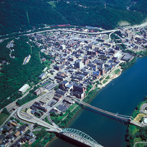
Lewis had contracted with a wagoner to haul a substantial part of his baggage from Pittsburgh to Wheeling. In 1803 there were only a few thousand miles of decent wagon roads in the seventeen states, and Wheeling was the western terminus of one of the newest of them.
Eulachon
Thaleichthys pacificus
by Joseph A. Mussulman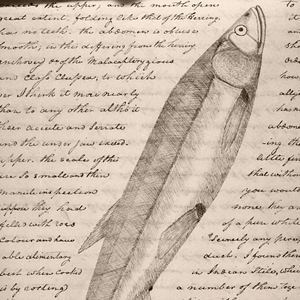
On 24 February 1806, Meriwether Lewis recorded that the Clatsop Indian chief, Coboway, came to the fort to sell some hats, some sturgeon, and “a species of small fish which now begin to run, and are taken in great quantities.”
Rainbow Falls by Air
"Pleasingly beautifull"
by Joseph A. Mussulman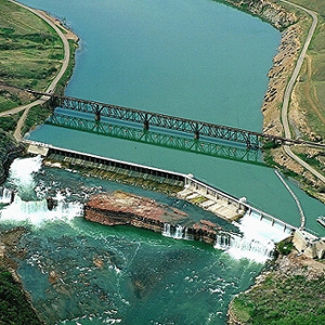
After briefly contemplating the Crooked Falls on 14 June 1805, Lewis followed the sound of “a tremendious roaring” to “one of the most beautifull objects in nature,” a fifty-foot-high cascade “with an edge as regular and as straight as if formed by art.”
Oxbow Bend
Land and water
by Joseph A. Mussulman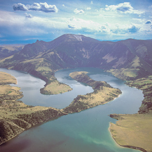
On 19 July 1805, Lewis ‘doubled’ around Oxbow Bend, then 30 feet lower and maybe one-fourth as wide as it is today. Behind the river’s curve, an ancient landmark on the Indian Old North Trail, still stands out.
The Blackfoot River by Air
Prairie of the knobs
by Joseph A. Mussulman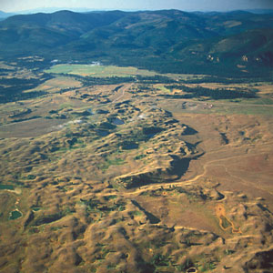
On 6 July 1806, Lewis’s eleven-man party had broken camp at the mouth of a Blackfoot River tributary they named Seamans Creek, after, and headed on up the river along the “road” that Indians living in the Rocky Mountains called the Cokahlahrishkit—the Road to the Buffalo.
Passing Hell’s Gate
Up the Blackfoot River
by Joseph A. Mussulman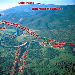
The continuation of the Northern Nez Perce Trail led from their camp at Travelers’ Rest to the plains near the Great Falls of the Missouri, saving hundreds of miles from the expedition’s 1805 route.
Crane Fly
Tipula abdominalis
by Joseph A. Mussulman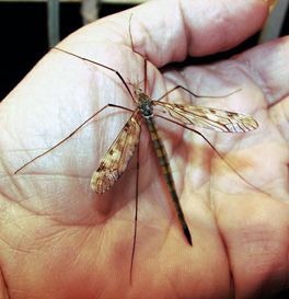
On 27 December 1805, Clark wrote: “Musquetors to day, or an insect So much the Size Shape and appearance of a Musquetor that we Could observe no kind of difference.”
Buffalo: Pioneer Uses
L&C to present-day
by Joseph A. Mussulman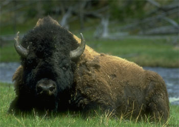
To some extent, the Corps of Discovery used buffalo much as the Indians did–for clothing, blankets, tents, saddle pads, and moccasins for both men and horses. After railroads, demand for buffalo robes soared, the iconic animal’s downfall was swift.
The Trapper Peaks
Bitterroot Mountain sentinels
by Joseph A. Mussulman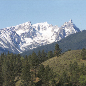
On 7 September 1805, the day after they left the Salish people at Ross’s Hole, the Corps proceeded north down the Bitterroot River valley. “The foot of the Snow toped mountains approach near the river on the left,” wrote Clark.
St. Louis by Air
The western gate
by Joseph A. Mussulman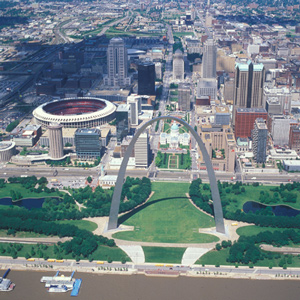
The expedition arrived on 7 December 1803, witnessed the transfer of Louisiana from Spain to the United States, and metaphorically passed through its western gate on 14 May 1804. They would not return until 23 September 1806.
The Niobrara River
Rushing river
by Joseph A. Mussulman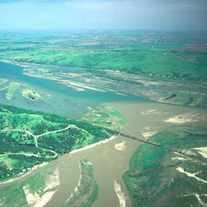
“We hoisted Sail,” wrote Ordway, and “ran verry fast a Short time. Broke our mast.” The party “came to” on the west side of the Niobrara. There the men made a new mast from the trunk of a tall, sturdy red cedar, which apparently lasted at least until they reached the Mandan villages.
Wolverines
Mystery mammal, Gulo gulo
by Joseph A. Mussulman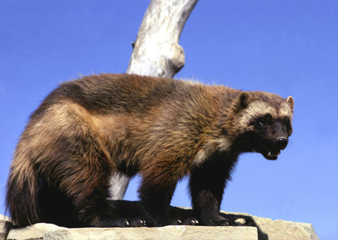
Lewis referred to it as a “tyger cat.” Even Carl Linneaus, the father of modern taxonomy, couldn’t decide whether the wolverine belonged to the weasel family or the dog family.
The Last Dance
What happened to the fiddle?
by Joseph A. Mussulman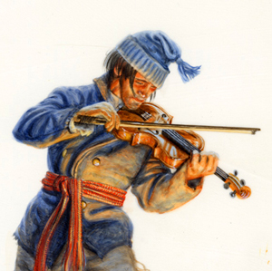
On 8 June 1806, Meriwether Lewis wrote of that evening, “we had the violin played, and [we] danced for the amusement of ourselves and the Indians.” Presumably, Pierre Cruzatte was the fiddler. It was the last mention Cruzatte’s playing the violin. Why?
Fleas
Pulex irritans
by Joseph A. Mussulman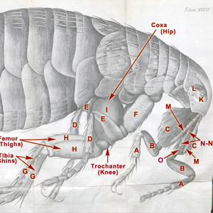
Nearly a century and a half before Lewis and Clark’s encounter with fleas en masse on the lower Columbia River, the little insect acquired an almost admirable, if not respectable, reputation, thanks to Hooke and his microscope.
Hares and Jackrabbits
Lepus species
by Joseph A. Mussulman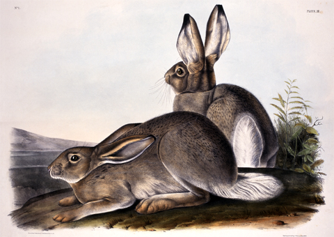
Lewis got his first close look at that “large hare of America,” when one of the Corps’ ace hunters, Private John Shields, bagged the first specimen more than 1,100 miles (by Clark’s estimate) up the Missouri River.
The Manual of Arms
Basic maneuvers for every soldier
by Joseph A. Mussulman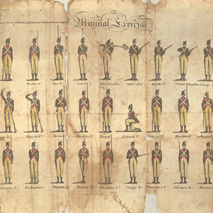
The first major objective of basic training was mastery of the “Manual Exercise,” or manual of arms. It involved 27 commands from the sergeant, calling for 56 motions by the recruit. The single command, “Prime and Load,” involved fifteen motions.
The Musselshell River
Sharp curve
by Joseph A. Mussulman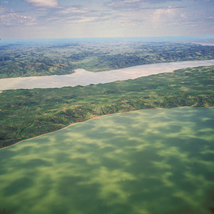
On 19 May 1805, the expedition camped on the east side of the neck, or “gouge,” in the Missouri River where the Musselshell River joins it. It had been an exhausting day.
Mapping the Yellowstone
by Joseph A. Mussulman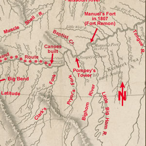
Clark’s map of 1814 shows his post-expeditionary conclusions regarding the lay of the land from just west of the Three Forks of the Missouri River, roughly 230 air miles eastward along the Yellowstone to the Tongue River.
Measuring Heights and Distances
From Owen's Dictionary
by Joseph A. Mussulman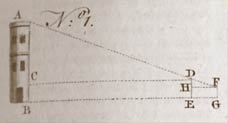
This article shows methods for measuring heights and distances as described by Owen’s Dictionary of Arts and Sciences (1754), a book in the expedition’s traveling library.
Western Whitetail Deer
Mysterious "longtailed deer"
by Joseph A. Mussulman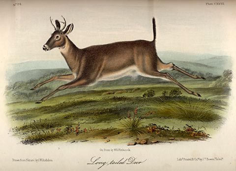
One of the most confusing terms in Lewis and Clark’s lexicon of quadrupeds was the adjective long-tailed—or longtailed. At the Three Forks on 29 July 1805, he compounded the ambiguity.
The Teton River
Clark's "Tanzy" and Lewis's "Rose"
by Joseph A. Mussulman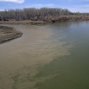
Clark first called it the “Tanzey.” Apparently Lewis dubbed it Rose River, for he noted that “the wild rose which grows here in great abundance in the bottoms of all these rivers is now in full bloom, and adds not a little to the beauty of the cenery.”
Smoking
Smoking on the expedition
by Joseph A. Mussulman, Kristopher K. Townsend
The captains would have to ration their dwindling supplies, and the smokers would have to extend their tobacco with leaves and inner bark from local plants and trees. The captains would also learn the endless variety of ceremonies practiced when sharing a pipe the People they met.
Beacon Rock
A remarkable, high and detached rock
by Joseph A. Mussulman![]()
“a remarkable high detached rock Stands in a bottom on the Stard [starboard, the navigator’s right] Side & about 800 feet high and 400 paces around”
Salmon
Four 'new' species
by Joseph A. Mussulman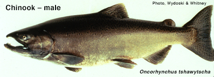
Meriwether Lewis and William Clark observed and described four fish belonging to the Salmonid family that were previously unknown to scientists, and that were basic foods for thousands upon thousands of Indians west of the Rockies.
York’s Fallout over Freedom
by Joseph A. Mussulman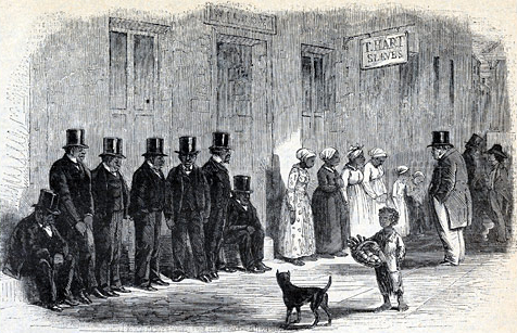
It is remarkable that we have no record of York’s words and thoughts. Insofar as the nineteenth century “slave narratives” were produced by Africans who had freed themselves, it may be conjectured that York did not leave a record of his thoughts and experiences because he was never freed.
Guard Duty
by Joseph A. Mussulman
During their journey up the Missouri to the Mandan villages, security procedures were outlined in the detachment orders of 26 May 1804. The detachment orders setting forth procedures for the security of Fort Clatsop, were issued on 1 January 1806.
Recruiting the Hunters
Finding soldiers that could hunt
by Joseph A. Mussulman
While traveling down the Ohio and wintering at Camp River Dubois, the captains searched for army recruits accustomed to the ways of the woods. If they were to survive, the expedition needed hunters.
Holidays on the Trail
Three special days
by Joseph A. Mussulman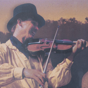
In a compromise with its multicultural makeup, the Corps of Discovery celebrated just three special days—Christmas Day, New Year’s Day, and Independence Day—and each must have been observed with a jovial mixture of traditions.
Defining ‘Savage’
Shades of meaning
by Joseph A. Mussulman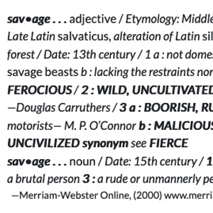
The word has two faces, one benign, the other brutish. The first springs from its etymological history, and represents the face of pure innocence. On the darker side, it is closer to the Latin cognate, saevus, meaning brutal, cruel, barbarous, violent and severe.
The Yellowstone Badlands
by Joseph A. Mussulman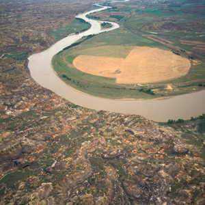
Around midday he passed the mouth of a tributary “40 yards wid Shallow and muddy,” the banks of which can be faintly discerned near the horizon in the picture, and identified it as the stream the Mandan chief Sheheke had called Oak-tar-pon-er.
Beaverhead Rock
Sacagawea's landmark?
by Joseph A. Mussulman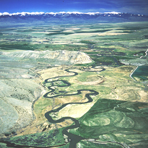
“The Indian woman recognized the point of a high plain to our right . . . . This hill she says her nation calls the beaver’s head from a conceived resemblance of its figure to the head of that animal.”
John Collins
Private
by Barbara Fifer, Joseph A. Mussulman
He had gotten off to a bad start, but apparently, the captains, or at least Clark, saw something in him that was worth saving. They would name Idaho’s Lolo Creek, Collins Creek.
Lolo on the Maps
Lou-Lou, Loo-Lo, or Lo Lo?
by Joseph A. Mussulman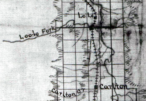
Whereas Lt. Mullan consistently referred to the creek as Lolo’s Fork, Isaac Stevens, in the published Reports and Surveys, and in all of the related maps, embellished Lo Lo with a supplementary u, making it “Lou Lou,” which led to the logical conclusion that the name was pronounced “Loo Loo.”
Apsáalooke Country
by Joseph A. Mussulman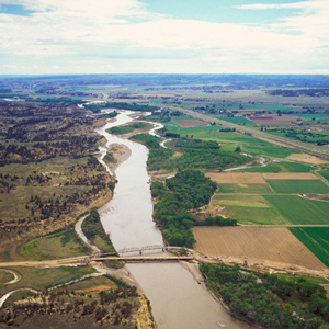
The Crow People called themselves Apsáalooke, sometimes heard as Absarokas or Absalookas, or “Children of the Large-beaked Bird.” Various early white travelers transcribed or defined the name differently, but the Apsáalooke maintain it refers to the raven. One of the oldest and most famous landmarks on Lewis and Clark’s route, now known officially, but erroneously, as Pompeys Pillar or, among the Apsáalooke, Iish-biia ah-naac’he’.
Pierre by Air
Standoff
by Joseph A. Mussulman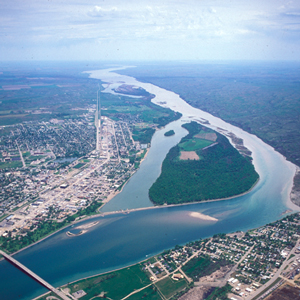
Lewis and Clark first met the Teton Sioux on 25 September 1804. One of Jefferson’s primary political objectives for the expedition was to create a peace treaty and trade agreement them, the most potent military and economic force on the lower Missouri.
The Mouth of the Ohio
Meeting of the waters
by Joseph A. Mussulman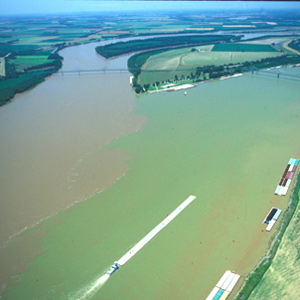
On the evening of 14 November 1803, Lewis and Clark camped on the point between the Ohio and Mississippi Rivers. By now they had rowed, poled, dragged, and occasionally sailed their boats a total of 981 miles.
The Two Medicine Formation
Dinosaur country
by Joseph A. Mussulman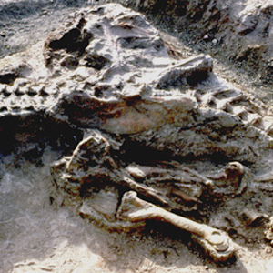
During his trips on the Marias in June 1805 and 1806, had he not been continually on the lookout for signs of those hostile Blackfeet Indians, Lewis just might have seen some fossils of marine shellfish.
Bismarck and Mandan
The main attraction
by Joseph A. Mussulman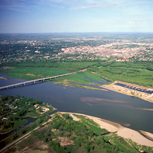
The Corps of Discovery arrived in the vicinity on 20 October 1804, having worked their way some 1,450 miles up the Missouri in 155 days. That day, wildlife was the main attraction.
Jerusalem Artichokes
Helianthus tuberosus
by Joseph A. Mussulman, Kristopher K. Townsend
The French explorer Samuel de Champlain found the vegetable growing in Indian gardens along the Saint Lawrence seaway and carried specimens of it back to France in 1603, where its root soon became a staple food for humans.
Jerking Meat
Preserving meat without refrigeration
by Joseph A. Mussulman, Kristopher K. Townsend
What did the captains mean when they say they stopped to jerk their meat? At the time of the expedition “jerk” simply stood for “dried meat.” This article includes a recipe.
Wild Ginger
Asarum canadense
by James L. Reveal, Joseph A. Mussulman
Lewis reported that a specimen of this plant “was taken the 1st of June at the mouth of the Osage River; it is known in this country by the name of the wild ginger.”
Chinookan Head Flattening
A most remarkable trait
by Joseph A. Mussulman, Kristopher K. Townsend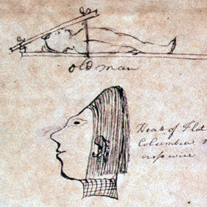
The most remarkable trait in the Clatsop Indian physiognomy, Lewis wrote on 19 March 1806, was the flatness and width of their foreheads, which they artificially created by compressing the heads of their infants, particularly girls, between two boards.
Where the Buffalo Roam
Anthem of the American West
by Joseph A. Mussulman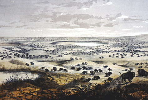
For more than a hundred years the American bison has been enshrined as a symbol of the American West in the first line of a song known around the world, “Home on the Range.”
The Knife River Villages
Marketplace
by Joseph A. Mussulman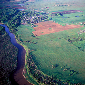
Reaching the mouth of the Knife River on 27 October 1804, the expedition arrived in the midst of a major agricultural center and marketplace for a huge mid-continental region. The five permanent earth lodge communities there offered a panorama of contemporary Indian life.
Edible Valerian
Valeriana edulis
by Joseph A. Mussulman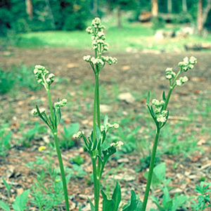
One of the roots obtained by George Drouillard on 21 August 1805 may have been a species of valerian (vuh-LEHR-ee-an), such as Valeriana edulis (vuh-leh-ree-AYE-nuh ed-YOU-lis), or edible valerian.
Western Meadowlark
Sturnella neglecta
by Joseph A. Mussulman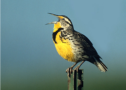
The species remained nameless until John James Audubon dubbed it neglecta because, he wrote in 1840, although “the existence of this species was known to the celebrated explorers of the west, Lewis and Clark . . . no one has since taken the least notice of it.”
Bad ‘humered’ Island
Change of heart
by Joseph A. Mussulman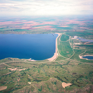
On the evening of 25 September 1804 after a negative encounter with the Lakota Sioux, the Corps camped on a nearby island Clark called “bad humered Island.” The next morning, the Indians had a change of heart.
The Freeman-Custis Expedition
The "Grand Excursion"
by Dan Flores, Joseph A. Mussulman
Narrated in both English and Spanish, Daniel Flores tells the story of a parallel, southern exploration now nearly forgotten.
The Jefferson Canyon
The fourth mountain gate
by Joseph A. Mussulman, Robert N. Bergantino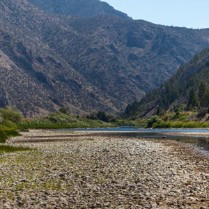
On 1 August 1805, Clark and the expedition’s flotilla of eight dugout canoes pushed up the Jefferson River through “a verrey high mountain which jutted its tremendious Clifts on either Side for 9 Miles, the rocks ragide.” They emerged into a “wide exte[n]sive vallie.”
Floyd’s Monument by Air
"Much Lamented"
by Joseph A. Mussulman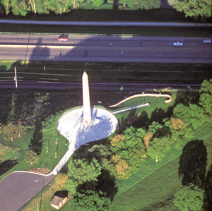
On 20 August 1804, the Corps proceeded thirteen miles, while young Floyd quickly grew worse. A little past noon they landed, and presently Floyd said, “I am going away.”
Fort Rock
Refuge at The Dalles
by Joseph A. Mussulman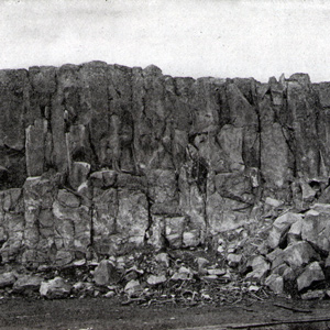
The party “Came too, under a high point of rocks on the Lard. Side below a creek”—Quenett (“salmon”), now Mill Creek—a “Situation well Calculated to defend our Selves,” and duly named their bivouac “Fort Rock Camp.”
Little Gate of the Mountain
Lewis's "second grand chain"
by Joseph A. Mussulman, Robert N. Bergantino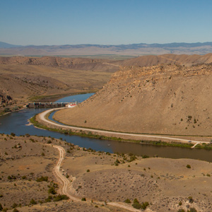
Before arriving at the three forks of the Missouri, Whitehouse wrote that they “passed some rough rockey hills, which we expect from the account we have from the Indian Woman that is with us, to be the commencement of the Second chain of the Rockey Mountains.
Crossing the Clark Fork
Lewis's rafting adventure
by Joseph A. Mussulman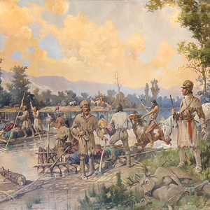
With every crossing they unavoidably drifted farther downstream. Lewis recounted the climactic rafting episode of the day.
Classifying Bighorn Sheep
by Joseph A. Mussulman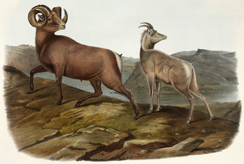
The first naturalist to publish an honest admission of uncertainty over the respective identities of the wild sheep and goat of North America was John Davidson Godman (1794-1830). Audubon and Bachman contributed illustrations and descriptions.
Gates of the Mountains by Air
"Gloomy aspect"
by Joseph A. Mussulman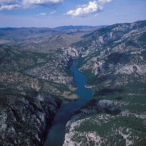
“The river appears to have forced it’s way through this immence body of solid rock for the distance of 5-3/4 miles,” Lewis observed.
Edward S. Curtis
Sepia-toned photogravure
by Joseph A. Mussulman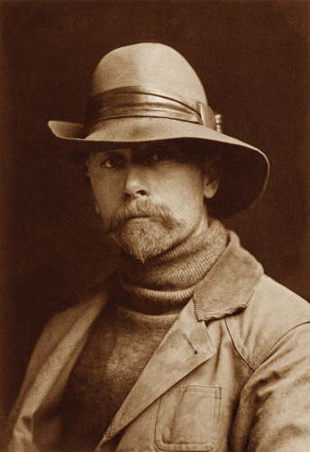
Edward Sheriff Curtis’s monumental collection of photographs was intended to be the ultimate documentation of the then-apparent end of traditional Indian life-ways. The consummation of thirty years’ work, it was enabled by substantial patronage from the wealthy financier J. P. Morgan.
The Vermillion River
The stream near Spirit Mound
by Joseph A. Mussulman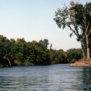
The Corps left the white pirogue at the mouth of this stream and followed it part of the way to the storied Spirit Mound. During the years between the day the Corps passed it and today, its mouth has migrated about 2.5 miles southeast.
Through Wallula Gap
Yelleppit and Sacagawea help out
by Joseph A. Mussulman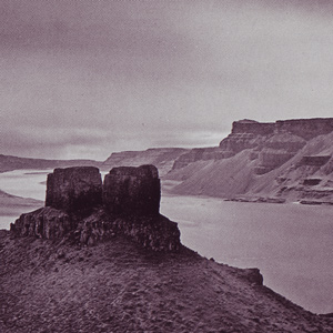
They encountered several rapids that nineteenth of October, including “a verry bad one” about two miles long. Clark climbed a 200-foot “clift” from which he could see many miles across the high desert.
The “Deserts of America”
by Joseph A. Mussulman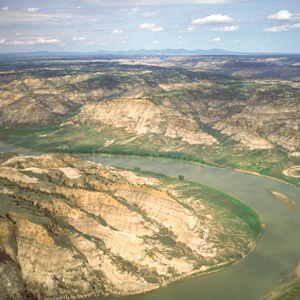
The men of the Corps of Discovery were fascinated by the varied textures, shapes and colors of the 200- to 300-foot cliffs that defined the river’s immediate borderlands. Clark judged from all he could see that “this Countrey may with propriety … be termed the Deserts of America.”
The Salmon River
A river of no return
by Joseph A. Mussulman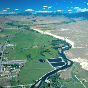
On the 23 August 1805, the centuries-old fantasy of a “water route across the continent for the purposes of commerce” dissolved in the roar of an unimaginable torrent–one of the most dangerous, unforgiving rivers in North America, that would later be called “The River of No Return.”
Cous
Lomatium cous
by Joseph A. Mussulman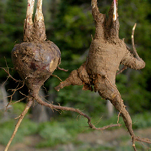
William Clark first mentioned the root cous on 1 November 1805, saying that native people living near the future Bonneville Dam site traded beads to obtain it from people up the Columbia River. To Clark, it was “cha-pel-el bread.”
The Salmon and Snake Villages
Side trip
by Joseph A. Mussulman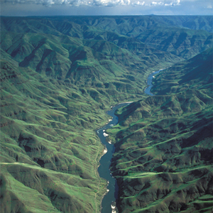
When the captains saw Nez Perces with several fresh chinook salmon, “fat and fine,” which the Indians said came from “Lewis’s River,” known today as the Salmon River, they dispatched Sgt. John Ordway and two privates to buy some.
Shipping the Supplies
Quartermaster Lewis
by Frank Muhly, Joseph A. Mussulman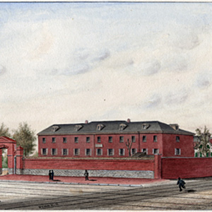
Considering all he had to do to prepare for the expedition, Lewis was fortunate in that he could rely on a small cadre of Army personnel to help him assemble, pack, and ship his supplies.
Columbia River near Blalock
Greatest chief
by Joseph A. Mussulman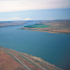
This scene’s most arresting feature is still the “high mountain of emence hight covered with Snow” on the photo’s horizon. Clark mistook it for Mount St. Helens. The Indians called the mountain Pahtoe. Since 1838 it has been known as Mount Adams.
Columbian Black-Tailed Deer
Odocoileus hemionus columbianus
by Joseph A. Mussulman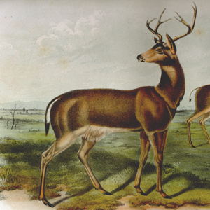
Lewis’s conviction that the “black tailed fallow deer of the coast” and the “common fallow deer” were two distinct species was sufficient to urge later investigators to try to clarify them.
Experience the Lewis and Clark Trail
The Lewis and Clark Trail Experience—our sister site at lewisandclark.travel—connects the world to people and places on the Lewis and Clark Trail.
![]()
Discover More
- The Lewis and Clark Expedition: Day by Day by Gary E. Moulton (University of Nebraska Press, 2018). The story in prose, 14 May 1804–23 September 1806.
- The Lewis and Clark Journals: An American Epic of Discovery (abridged) by Gary E. Moulton (University of Nebraska Press, 2003). Selected journal excerpts, 14 May 1804–23 September 1806.
- The Lewis and Clark Journals. by Gary E. Moulton (University of Nebraska Press, 1983–2001). The complete story in 13 volumes.
This site is provided as a public service by the
![]()
Lewis and Clark Trail Alliance
with additional funding from the following: